 Filter: Categories of Wisconsin Historical Images
Filter: Subject of Farms
Filter: Creator Name of Unknown
Filter: Year of 1800-1899
Filter: Year of 1870-1879
Filter: Categories of Wisconsin Historical Images
Filter: Subject of Farms
Filter: Creator Name of Unknown
Filter: Year of 1800-1899
Filter: Year of 1870-1879
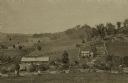
| Date: | 1875 |
|---|---|
| Description: | View from a distance of a farm in a valley owned by Alex(ander?) Smith. There is a wooden fence in the foreground surrounding the farm. |
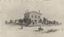
| Date: | 1871 |
|---|---|
| Description: | The building has a fence around it and the yard is filled with trees. Pedestrians are in the road, as well as a man riding a horse. |
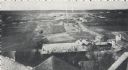
| Date: | 1870 |
|---|---|
| Description: | Elevated view from rooftops of what was known as Watertown Plank road, looking west from about North 35th Street. Several homes, and many open fields occup... |

| Date: | 1879 |
|---|---|
| Description: | This hand-colored profile shows the depth and the fall of an approximately 14 mile long stretch of the Beaver Dam and Crawfish rivers in the towns of Lowel... |

| Date: | 1876 |
|---|---|
| Description: | Map shows townships and sections, landownership and acreages, roads, railroads, post offices, and farms. Sections appear in pink, yellow, and blue. On the ... |

| Date: | 1878 |
|---|---|
| Description: | View towards a house and farm buildings. Caption reads: "Barneveld, Wis. Vic[inity]. Ridgeway Twp [township], Hwy [Highway] K. House built 1878 by William ... |

| Date: | 1878 |
|---|---|
| Description: | An etching of the farm and residence of Mrs. C.E. Packman and her son. |
If you didn't find the material you searched for, our Library Reference Staff can help.
Call our reference desk at 608-264-6535 or email us at: