 Filter: Categories of Wisconsin Historical Images
Filter: Subject of Farmhouses
Filter: County of La Crosse
Filter: Categories of Wisconsin Historical Images
Filter: Subject of Farmhouses
Filter: County of La Crosse
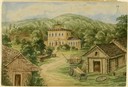
| Date: | 1859 |
|---|---|
| Description: | Due to rainy weather, Hölzlhuber stayed a night in the home of Heinrich Cordes, who had purchased his land from an Irishman and built "a pretty brick house... |

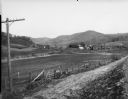
| Date: | 11 1951 |
|---|---|
| Description: | Aerial view of US Highway 14 southeast of La Crosse descending into Mormon Coulee. The original caption of the print, which is undated, describes the road ... |

| Date: | 1938 |
|---|---|
| Description: | A view of a farm in the "Coulee Country" near La Crosse during the spring. There is a long ditch in the foreground. |
| Date: | |
|---|---|
| Description: | View across dirt road of farms and farm buildings in a valley. |

| Date: | 1857 |
|---|---|
| Description: | Map of La Crosse County, Wisconsin showing village plat, farm houses, schools, roads, railroads, township names (New Amsterdam, Dacota, Minnesota, Driesbac... |
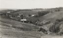
| Date: | 1936 |
|---|---|
| Description: | View down hill towards valley of farming country in the “Coulee Region.” |
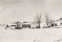
| Date: | 1920 |
|---|---|
| Description: | Winter scene with snow-covered fields at the Thomas Pederson farm, near Holmen. |
If you didn't find the material you searched for, our Library Reference Staff can help.
Call our reference desk at 608-264-6535 or email us at: