 Filter: Categories of Wisconsin Historical Images
Filter: Subject of Farmhouses
Filter: County of Dane
Filter: Categories of Wisconsin Historical Images
Filter: Subject of Farmhouses
Filter: County of Dane

| Date: | |
|---|---|
| Description: | You came to know that book by its covered distance, well remembered by the measure of the trudging barefoot mile |

| Date: | 02 18 1964 |
|---|---|
| Description: | Mrs. Jay Meredith Fitts sitting in an antique Victorian chair in her old farm house on Old Sauk Road near Gammon Road (the old Carl Meyer place), preparing... |

| Date: | 02 18 1964 |
|---|---|
| Description: | Master bedroom in the George Fitts family's rented brick farmhouse on Old Sauk Road near Gammon Road. The farmhouse was originally owned by Carl Meyer. |

| Date: | 02 18 1964 |
|---|---|
| Description: | Chandelier in the farmhouse rented by George Fitts on Old Sauk Road near Gammon Road. The farm house was originally owned by Carl Meyer. |

| Date: | 02 18 1964 |
|---|---|
| Description: | Brick farm house on Old Sauk Road near Gammon Road (the old Carl Meyer place). Rented to the George Meyer family in 1961. |

| Date: | 02 18 1964 |
|---|---|
| Description: | Den room in the brick farm house on Old Sauk Road near Gammon Road rented to the George Fitts family in 1961. The room was the front parlor of the house or... |

| Date: | |
|---|---|
| Description: | This is number one in Stanley Hanks' collection of four prints of the Keystone House in Shorewood. This historic stone farmhouse, at 901 University Bay Dri... |

| Date: | |
|---|---|
| Description: | This is number two in Stanley Hanks' collection of four prints of the Keystone House in Shorewood. This historic stone farmhouse, at 901 University Bay Dri... |

| Date: | |
|---|---|
| Description: | This is number three in Stanley Hanks' collection of four prints of the Keystone House in Shorewood. This historic stone farmhouse, at 901 University Bay D... |

| Date: | 1927 |
|---|---|
| Description: | This Blue line print map shows trade area boundaries, lakes, farm homes, railways, high schools, public highways, and townships. A symbol key is included i... |
| Date: | |
|---|---|
| Description: | A vintage view and a modern view of 4718 Odana Road, presented as a pair. The vintage view shows the Piper Brothers Farm. The modern view shows a house wit... |

| Date: | 10 18 1978 |
|---|---|
| Description: | View down Old Sauk Pass towards a house in a valley during a rainstorm in rural Wisconsin. |

| Date: | 1950 |
|---|---|
| Description: | View through room towards Leonore Middleton, in another room, holding a majolica plate. She is sitting next to an open dish dresser which holds other potte... |
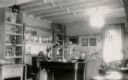
| Date: | 1930 |
|---|---|
| Description: | Sunlight and a ceiling fixture provide light for a parlor furnished in an Early American style. A portrait of George Washington is hanging on the far wall.... |

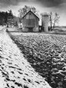
| Date: | 1951 |
|---|---|
| Description: | View from slope towards a farm, with barn, silos, and farmhouse. Caption reads: "Mt. Horeb (Vicinity) Wis. Highway 92, c. 1951-1955." |

| Date: | |
|---|---|
| Description: | View across fence through trees towards fields and farm buildings. |

| Date: | 12 16 1958 |
|---|---|
| Description: | Grandma Bayles rolling out Christmas cookies in the farm kitchen with Ann Denise, 3, and baby Gale, 5 months, nearby. One in a series of images depicting C... |

| Date: | 07 23 1960 |
|---|---|
| Description: | View from a bluff looking south. A highway is on the right; one farm building is among a stand of trees at the bottom of the hill. |
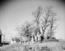
| Date: | 05 13 1961 |
|---|---|
| Description: | View of several trees growing behind a rocky outcropping. In the background on the left is a farmhouse and farm buildings, and a tower for what may be a wi... |
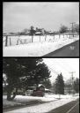
| Date: | 1979 |
|---|---|
| Description: | A barn and silo, on a snow covered farm along Highway 78, between Mt. Horeb and Black Earth. The farmhouse is behind the barn. A barbed wire fence lines th... |
If you didn't find the material you searched for, our Library Reference Staff can help.
Call our reference desk at 608-264-6535 or email us at: