 Filter: Categories of Wisconsin Historical Images
Filter: Subject of Farmhouses
Filter: Creator Name of Unknown
Filter: Subject of valleys
Filter: Categories of Wisconsin Historical Images
Filter: Subject of Farmhouses
Filter: Creator Name of Unknown
Filter: Subject of valleys
| Date: | |
|---|---|
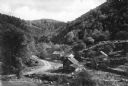
| Description: | View of a mountain pass named Dunville Notch. A group of farmhouses are located among trees and a dirt road. |
| Date: | |
|---|---|
| Description: | View of a mountain pass called Dunville Notch. A group of farmhouses are located among trees and a dirt road. Men gather near parked cars and a sign near t... |

| Date: | |
|---|---|
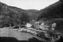
| Description: | Farm buildings standing near the fields at Glen Farm in Dorset Hollow. |
| Date: | 1936 |
|---|---|
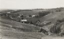
| Description: | View down hill towards valley of farming country in the “Coulee Region.” |

| Date: | |
|---|---|
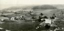
| Description: | View from a dirt road towards a field in a valley of low bluffs. Farm buildings are near a base of the bluffs at the far edge of the field. |
| Date: | 1930 |
|---|---|
| Description: | Aerial view of two farms, with fields and barns in a valley. This image appeared in Joseph Schafer's 1932 book The Wisconsin Lead Region, on a photo... |

| Date: | 1970 |
|---|---|
| Description: | View towards farm buildings, with snow-capped mountains in the distance. |
If you didn't find the material you searched for, our Library Reference Staff can help.
Call our reference desk at 608-264-6535 or email us at: