 Filter: Categories of Wisconsin Historical Images
Filter: Subject of Farmhouses
Filter: Creator Name of Unknown
Filter: Subject of roads
Filter: Categories of Wisconsin Historical Images
Filter: Subject of Farmhouses
Filter: Creator Name of Unknown
Filter: Subject of roads
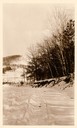
| Date: | 1911 |
|---|---|
| Description: | Winter scene with a snow-covered road and trees near Taliesin, the home of Frank Lloyd Wright, with a farmhouse in the distance. Taliesin is located in the... |
| Date: | |
|---|---|
| Description: | Elevated view of barn and farmer's house of John Bass. |
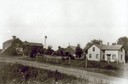
| Date: | 1912 |
|---|---|
| Description: | Exterior of the Droster farm located on Felland Road. The house was built in 1854. |
| Date: | 11 16 1989 |
|---|---|
| Description: | McNinch Road, an unpaved road near the Little Wolf River crossing in the town of Wyoming. |

| Date: | 1900 |
|---|---|
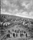
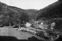
| Description: | Distant view from hill looking down toward small village's main street and surrounding countryside. |

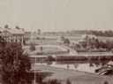
| Date: | 1910 |
|---|---|
| Description: | Elevated view of town and surrounding hills taken from Flat Rock. Caption reads: "Claremont, from Flat Rock." |
| Date: | 1909 |
|---|---|
| Description: | Painting of an elevated view of Pilgrims and Native Americans meeting in a town. |
| Date: | |
|---|---|
| Description: | View looking north from a covered bridge, including a rocky stream-bed and a tree-lined dirt road with houses and other wooden buildings. Caption reads, "V... |

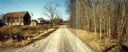
| Date: | 1915 |
|---|---|
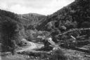
| Description: | Low perspective of a dirt country road curving into the distance. The road is bordered by fields and scattered wooden buildings while a solitary figure ap... |
| Date: | 1900 |
|---|---|
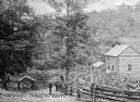
| Description: | View downhill toward four men standing on the side of the road, with two men leaning against a fence, and one sitting on the fence. To the right is a cornf... |

| Date: | |
|---|---|
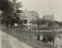
| Description: | Posing together from left to right are Elinora, Nellie Arms (aunt of Lewis Arms), and Bonnie Childs. They are at Nellie and Bernard Arms's farm. There is a... |

| Date: | 08 21 1952 |
|---|---|
| Description: | From left to right are Lewis, Nellie and Bernard Arms posing behind a convertible on Old Lake Road, with Bernard and Nellie's house in the background. |
| Date: | |
|---|---|
| Description: | View of a mountain pass named Dunville Notch. A group of farmhouses are located among trees and a dirt road. |
| Date: | |
|---|---|
| Description: | View of a mountain pass called Dunville Notch. A group of farmhouses are located among trees and a dirt road. Men gather near parked cars and a sign near t... |
| Date: | |
|---|---|
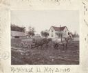
| Description: | View of a horse-drawn wagon loaded with hay. Farm buildings can be seen beyond fields and horses. |
| Date: | 09 09 1922 |
|---|---|
| Description: | The farmhouse of the Wetherby Cranberry Company. At the time the farmhouse was owned by H. Kissinger. In the foreground is the corner of the water reservoi... |

| Date: | 1898 |
|---|---|
| Description: | Rear view of a man driving a horse-drawn wagon filled with pipe on a muddy, rutted dirt road. A split-rail fence can be seen on both sides of the road and ... |
| Date: | 1898 |
|---|---|
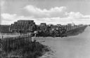
| Description: | Two men sit in a wagon pulled by four horses, which is stuck in the mud. Farm buildings are on the left and a farmhouse is on the right. This image was ent... |

| Date: | 1897 |
|---|---|
| Description: | This 1897 map of Sawyer County, Wisconsin, shows the township and range system, sections, roads, farm houses, camps, school houses, dams, bridges, Indian r... |
If you didn't find the material you searched for, our Library Reference Staff can help.
Call our reference desk at 608-264-6535 or email us at:
