 Filter: Categories of Wisconsin Historical Images
Filter: Subject of Factories
Filter: Year of 2000-Present
Filter: Year of 2000-2009
Filter: Categories of Wisconsin Historical Images
Filter: Subject of Factories
Filter: Year of 2000-Present
Filter: Year of 2000-2009

| Date: | 2007 |
|---|---|
| Description: | This map of Cedarbug is a bird's-eye map with 8 inset views and an index. The map is a print out of the original map dated 1892 held at the Cedarburg Cultu... |
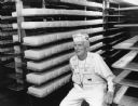
| Date: | 06 2000 |
|---|---|
| Description: | Ralph Widmer, an excellent spokesman for Widmer Cheese, talks about curing cheese. |

| Date: | 2000 |
|---|---|
| Description: | This map shows the industrial area along the Menominee River and canals. Industrial buildings are shown in orange and labeled in red. Other areas are shown... |
If you didn't find the material you searched for, our Library Reference Staff can help.
Call our reference desk at 608-264-6535 or email us at: