 Filter: Categories of Wisconsin Historical Images
Filter: Subject of Factories
Filter: Year of 1900-1999
Filter: Subject of islands
Filter: Categories of Wisconsin Historical Images
Filter: Subject of Factories
Filter: Year of 1900-1999
Filter: Subject of islands

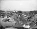
| Date: | 1910 |
|---|---|
| Description: | Bird's-eye view looking east, with Washburn Harbor at center and Chequamegon Bay in Lake Superior covering most of the upper image. Streets with buildings... |
| Date: | 09 29 1963 |
|---|---|
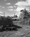
| Description: | The Menasha Woodenware plant and water tower on Doty Island from across the Fox River canal, with a small railroad dolly in the foreground. |
| Date: | 09 29 1963 |
|---|---|
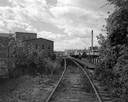
| Description: | View down railroad tracks towards the railroad bridge, with industrial plants on Doty Island. |
| Date: | 1955 |
|---|---|
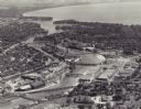
| Description: | Aerial view of "the island" with the Marathon Corporation paper mills. The Fox River flowing out of Lake Winnebago separates the two cities, Neenah and Men... |
| Date: | 1969 |
|---|---|
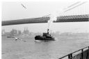
| Description: | The Island's Edge, Williamsburg Bridge, East River. |
| Date: | 10 28 1938 |
|---|---|
| Description: | Elevated view of bay shoreline, with dwellings along the bank. A few boats are in the river. In the background is a factory with a smokestack and railroad ... |

| Date: | 1902 |
|---|---|
| Description: | This map is a chart of Milwaukee Harbor that displays local streets, bridges, roads, railroads, public buildings, businesses, factories, dry docks, parks, ... |
If you didn't find the material you searched for, our Library Reference Staff can help.
Call our reference desk at 608-264-6535 or email us at: