 Filter: Categories of Wisconsin Historical Images
Filter: Subject of Factories
Filter: Year of 1800-1899
Filter: Subject of hills
Filter: Categories of Wisconsin Historical Images
Filter: Subject of Factories
Filter: Year of 1800-1899
Filter: Subject of hills

| Date: | 1886 |
|---|---|
| Description: | Bird's-eye view of Bayfield, county seat of Bayfield County. On the lower left side is an inset for Bayfield and the Apostle Islands. |

| Date: | 1867 |
|---|---|
| Description: | Birds eye drawing of Fond du Lac depicts street names and street layouts, houses, buildings, trees, and the Fond du Lac River. A reference key at the botto... |

| Date: | 1885 |
|---|---|
| Description: | Bird's-eye view of Sheboygan, with inset of J.J. Volrath Manufacturing Company. |

| Date: | 1885 |
|---|---|
| Description: | Bird's-eye map of Waupun on the Rock River. There is an inset at top center of "Althouse, Wheeler & Co., Windmills and Pumps." |

| Date: | 1872 |
|---|---|
| Description: | Birds-eye drawing of Eau Claire depicts street names and street locations, houses, trees, bridges, piers, canals, railroads, and the Chippewa and Eau Clair... |

| Date: | 12 21 1882 |
|---|---|
| Description: | Bird's-eye map of Kaukauna, from the Appleton Post Annual Review. |
| Date: | 1882 |
|---|---|
| Description: | First building of the 27th Street plant. |
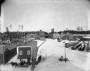
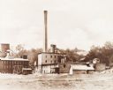
| Date: | 1898 |
|---|---|
| Description: | Elevated winter view of the Leinenkugel Brewery seen "from top of Mill." Originally called "Spring Brewery," Jacob Leinenkugel opened his brewery in 1867 i... |
If you didn't find the material you searched for, our Library Reference Staff can help.
Call our reference desk at 608-264-6535 or email us at: