Filter: Categories of Wisconsin Historical Images
Filter: Subject of Factories
Filter: Year of 1800-1899
Filter: County of Jefferson
Filter: Categories of Wisconsin Historical Images
Filter: Subject of Factories
Filter: Year of 1800-1899
Filter: County of Jefferson

| Date: | 1893 |
|---|---|
| Description: | Bird's-eye map of Jefferson, looking north. Crayfish River at left and center, Rock River from upper center to bottom center, joins at left of center; thir... |
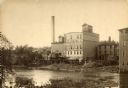
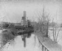
| Date: | 1890 |
|---|---|
| Description: | View across water towards the Empire Mill. Alongside the building are railroad cars at a loading dock. The signs on the mill read: "Globe", "Globe's Empire... |

| Date: | 09 1884 |
|---|---|
| Description: | Sanborn map of Fort Atkinson including Barrie, Germany, and North Water Streets. |

| Date: | 09 1884 |
|---|---|
| Description: | Sanborn map of Fort Atkinson including South Water and Milwaukee Streets. |
If you didn't find the material you searched for, our Library Reference Staff can help.
Call our reference desk at 608-264-6535 or email us at: