 Filter: Categories of Wisconsin Historical Images
Filter: Subject of Factories
Filter: Community of Superior
Filter: Categories of Wisconsin Historical Images
Filter: Subject of Factories
Filter: Community of Superior

| Date: | 1913 |
|---|---|
| Description: | Bird's-eye map of Superior. "The New Steel Center." |
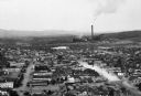
| Date: | |
|---|---|
| Description: | Elevated view of the city with a smokestack in the distance. |

| Date: | 1934 |
|---|---|
| Description: | This map shows industrial points of interest in Superior. The top of the map reads: "Superior, Douglas County, Wisconsin, as this Industrial Tour map indic... |

| Date: | 1901 |
|---|---|
| Description: | This map shows streets, industrial buildings, a portion of Lake Superior and other lakes, bays, and rivers in portions of Duluth and Superior. Relief is sh... |

| Date: | 1892 |
|---|---|
| Description: | A Sanborn map of St. Louis, which is six miles southwest of South Superior. |
If you didn't find the material you searched for, our Library Reference Staff can help.
Call our reference desk at 608-264-6535 or email us at: