Filter: Categories of Wisconsin Historical Images
Filter: Subject of Express highways
Filter: Year of 1900-1999
Filter: Year of 1930-1939
Filter: Categories of Wisconsin Historical Images
Filter: Subject of Express highways
Filter: Year of 1900-1999
Filter: Year of 1930-1939
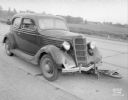
| Date: | 09 04 1938 |
|---|---|
| Description: | Accident scene on Highway 12-18 one-half mile east of the Dane County fairgrounds. Close-up of front of automobile, with bicycle under the car. Katherine B... |
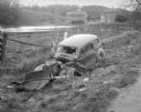
| Date: | 10 23 1937 |
|---|---|
| Description: | Close-up of damaged Chevrolet in a ditch next to Highway 12 near Highway KP & Roxbury, looking north, with a farmstead in the background. |
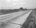
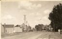
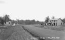
| Date: | 08 29 1933 |
|---|---|
| Description: | US Hwy 12 looking southwest, showing corn fields, McVicar Photo Service case, Sinclair sign and a good view of farm buildings in the background. |
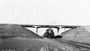
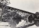
| Date: | 11 16 1939 |
|---|---|
| Description: | Highway bridge on USH 41 with a train pulled by locomotive #496 traveling under the span. |

| Date: | 1930 |
|---|---|
| Description: | View of bridge and Brule River monument. Placed where the Brule River is crossed by the Memorial Highway from Superior to Brule and Ashland (Highway 2). |

| Date: | 1930 |
|---|---|
| Description: | Elevated view of two men driving an International truck on U.S. Highway 75 between Breckenridge and Moorehead in Minnesota. |
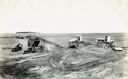
| Date: | 1930 |
|---|---|
| Description: | Construction equipment and dump trucks belonging to the Wagner Erling Company work on the beginnings of Highway 77 in South Dakota. |

| Date: | 1937 |
|---|---|
| Description: | Official state highway map, with insets of cities. |

| Date: | 1930 |
|---|---|
| Description: | Exterior view of the Triangle filling station on Highway 12, which sold gasoline, ice, and other items. A man stands in front by the gas pump, and a map of... |
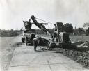
| Date: | 11 11 1937 |
|---|---|
| Description: | A man shovels dirt from a highway five miles north of Richmond next to an Austin-Western Badger shovel powered by a McCormick-Deering engine. The equipmen... |
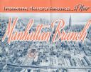
| Date: | 1937 |
|---|---|
| Description: | Cover of a brochure celebrating a new International Harvester Manhattan branch, featuring an aerial photograph of Manhattan, including the corner of West 4... |
| Date: | 1936 |
|---|---|
| Description: | View looking down Highway 77 at Clam Lake. On the left is a one-story building, Day's Service Station. On the right are two buildings, the one-story Standa... |

| Date: | 1931 |
|---|---|
| Description: | This map of south central Wisconsin shows lakes, rivers, cities, villages, highways and roads, railroads, Indian mounds, and points of scenic and historic ... |

| Date: | 1933 |
|---|---|
| Description: | This road map shows state and county roads in Wisconsin, northern Illinois, northeastern Iowa, eastern Minnesota, and the western portion of Michigan's Upp... |

| Date: | 1933 |
|---|---|
| Description: | This map of Wisconsin and eastern Minnesota identifies federal and state highways in the area. Railroads are shown with the mileage between stops indicated... |

| Date: | 1935 |
|---|---|
| Description: | This three-part map from the U.S. Bureau of Public Roads identifies highways in Wisconsin that have been improved, indicating those which are federal highw... |

| Date: | 1935 |
|---|---|
| Description: | "Drott's conservation guide" map shows the locations of Indian reservations, parks, fish hatcheries, forests, lookout towers, Wisconsin Conservations Commi... |

| Date: | 1936 |
|---|---|
| Description: | This 1936 Wisconsin Conservation Dept. map shows the locations of state forestry Civilian Conservation Corps (CCC) camps, closed state forestry CCC camps, ... |
If you didn't find the material you searched for, our Library Reference Staff can help.
Call our reference desk at 608-264-6535 or email us at: