 Filter: Categories of Wisconsin Historical Images
Filter: Subject of Express highways
Filter: Year of 1900-1999
Filter: Categories of Wisconsin Historical Images
Filter: Subject of Express highways
Filter: Year of 1900-1999

| Date: | 06 1960 |
|---|---|
| Description: | "Famous Schreiner's Restaurant of Fond du Lac had this sign on Highway 41 forty-five years ago." |
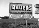
| Date: | 06 1960 |
|---|---|
| Description: | "Bauer's Restaurant in Campbellsport was a landmark in the area. The owner, 'Mush' Bauer, was an extremely overweight man." |

| Date: | 06 1960 |
|---|---|
| Description: | "The M & E Restaurant, now closed, located near the intersection of Highway 41 & 28, was operated by Milton & Elda Coulter." |

| Date: | 1923 |
|---|---|
| Description: | This map shows trails, some in red, for automobiles. The right margin includes a key of markings as well as Minnesota and Wisconsin Highway signs. Communit... |

| Date: | 1915 |
|---|---|
| Description: | A map of Wisconsin that shows 1,900 miles of national highways proposed for the state. The map also includes the names and locations of towns and cities th... |

| Date: | 1921 |
|---|---|
| Description: | Two maps, the first one on the left shows the state highway system, and the route and location of the proposed Northern Lakes Park. The second map shows a ... |

| Date: | 06 1980 |
|---|---|
| Description: | "In the foreground is the intersection of Hwy D & Hwy 175. Beyond it is Allen Road." |
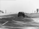
| Date: | 02 1979 |
|---|---|
| Description: | Winter scene with a car on Hwy. 41 near in Dodge Co., Wisconsin. Caption: "On a cold, windy day, snow drifts across Hwy 41." |
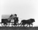
| Date: | 06 1982 |
|---|---|
| Description: | "Bill Zahn of Juneau organized this wagon train as it traveled on Y near Knowles." |
| Date: | 06 1982 |
|---|---|
| Description: | "Bill Zahn of Juneau organized this wagon train as it traveled on Y near Knowles." |
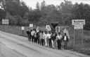
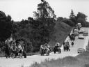
| Date: | 1966 |
|---|---|
| Description: | Marchers of Obreros Unidos (United Workers) leaving Wautoma and walking towards Madison along Highway 21 to petition lawmakers to hold farms and food indus... |

| Date: | 03 1984 |
|---|---|
| Description: | "Traveling west over the Theresa Marsh, Hwy 28 intersects Hwy 175 at this intersection." |

| Date: | 1923 |
|---|---|
| Description: | This early road map shows the system of roads in Wisconsin, northern Illinois, northeastern Iowa, southeastern Minnesota, and the western portion of Michig... |

| Date: | 1931 |
|---|---|
| Description: | This map of south central Wisconsin shows lakes, rivers, cities, villages, highways and roads, railroads, Indian mounds, and points of scenic and historic ... |

| Date: | 1933 |
|---|---|
| Description: | This road map shows state and county roads in Wisconsin, northern Illinois, northeastern Iowa, eastern Minnesota, and the western portion of Michigan's Upp... |

| Date: | 1933 |
|---|---|
| Description: | This map of Wisconsin and eastern Minnesota identifies federal and state highways in the area. Railroads are shown with the mileage between stops indicated... |

| Date: | 1935 |
|---|---|
| Description: | This three-part map from the U.S. Bureau of Public Roads identifies highways in Wisconsin that have been improved, indicating those which are federal highw... |

| Date: | 1935 |
|---|---|
| Description: | "Drott's conservation guide" map shows the locations of Indian reservations, parks, fish hatcheries, forests, lookout towers, Wisconsin Conservations Commi... |

| Date: | 1936 |
|---|---|
| Description: | This 1936 Wisconsin Conservation Dept. map shows the locations of state forestry Civilian Conservation Corps (CCC) camps, closed state forestry CCC camps, ... |
If you didn't find the material you searched for, our Library Reference Staff can help.
Call our reference desk at 608-264-6535 or email us at:
