Filter: Categories of Wisconsin Historical Images
Filter: Subject of Express highways
Filter: Subject of water
Filter: Categories of Wisconsin Historical Images
Filter: Subject of Express highways
Filter: Subject of water
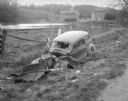
| Date: | 10 23 1937 |
|---|---|
| Description: | Close-up of damaged Chevrolet in a ditch next to Highway 12 near Highway KP & Roxbury, looking north, with a farmstead in the background. |

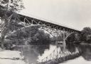
| Date: | 1930 |
|---|---|
| Description: | View of bridge and Brule River monument. Placed where the Brule River is crossed by the Memorial Highway from Superior to Brule and Ashland (Highway 2). |

| Date: | 1955 |
|---|---|
| Description: | Aerial view of La Crosse, with Onalaska in the background. The highway is U.S. Highway 53 and the State Highway 35. |

| Date: | 09 1962 |
|---|---|
| Description: | The Mississippi River along Highway 35. |

| Date: | 1941 |
|---|---|
| Description: | Official highway map of Wisconsin, "the playground of the Midwest," showing the state transportation network prior to World War II. |
| Date: | 1960 |
|---|---|
| Description: | Excavation for bridge column footings for the Mirror Lake Bridge. |

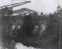
| Date: | 1960 |
|---|---|
| Description: | Aerial view of the construction of the interstate highway near Mirror Lake, showing only the early stages of the bridge construction. |
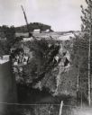
| Date: | 11 16 1960 |
|---|---|
| Description: | Elevated view of the interstate highway bridge construction at Mirror Lake showing the concrete footings halfway down the embankment. |
| Date: | 1979 |
|---|---|
| Description: | Interstate I-90 and State Highway 35 at La Crosse. |

| Date: | 04 01 1975 |
|---|---|
| Description: | The bridge over the Milwaukee Harbor named in honor of former Mayor Daniel Hoan. The bridge was constructed between 1970 and 1972, but during the period de... |
| Date: | 06 1977 |
|---|---|
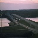
| Description: | A view of the St. Croix River crossing at Hudson during the development of the Interstate Bridge. The old eastbound bridge seen here was built in 1951 whil... |

| Date: | 1913 |
|---|---|
| Description: | Wisconsin map showing fifteen hundred miles of national highways proposed by the National Highways Association. Scale: 1:2,500,000. These highways will dir... |

| Date: | 1937 |
|---|---|
| Description: | Official state highway map, with insets of cities. |

| Date: | 1961 |
|---|---|
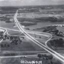
| Description: | View over beltline of University of Wisconsin-Madison Arboretum along Lake Wingra. Lake Mendota is on upper left, and Lake Monona is on the right, with the... |
| Date: | 1937 |
|---|---|
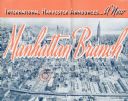
| Description: | Cover of a brochure celebrating a new International Harvester Manhattan branch, featuring an aerial photograph of Manhattan, including the corner of West 4... |
| Date: | 1972 |
|---|---|
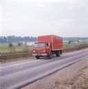
| Description: | Color photograph of a man driving an International truck past a body of water in what appears to be a golf course. |

| Date: | 1944 |
|---|---|
| Description: | Continental Transportation Lines, Inc. operating an International semi-truck (tractor-trailer) on a road with a hazy view of a bridge, a body of water and ... |

| Date: | 1944 |
|---|---|
| Description: | Continental Transportation Lines, Inc. operating an International truck tractor on an urban highway. A bridge, houses and industrial buildings are in the b... |

| Date: | 1923 |
|---|---|
| Description: | This map shows trails, some in red, for automobiles. The right margin includes a key of markings as well as Minnesota and Wisconsin Highway signs. Communit... |
If you didn't find the material you searched for, our Library Reference Staff can help.
Call our reference desk at 608-264-6535 or email us at: