Filter: Categories of Wisconsin Historical Images
Filter: Subject of Express highways
Filter: Subject of travel
Filter: Categories of Wisconsin Historical Images
Filter: Subject of Express highways
Filter: Subject of travel
| Date: | |
|---|---|
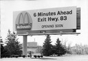
| Description: | A billboard advertising the opening of a particular McDonald's restaurant. Express highways promoted the emergence of large signs that could be read at a d... |

| Date: | 1941 |
|---|---|
| Description: | Official highway map of Wisconsin, "the playground of the Midwest," showing the state transportation network prior to World War II. |

| Date: | 1969 |
|---|---|
| Description: | Advertising poster for International trucks and campers. Features a color photograph of a man and woman with a Travellall that is hooked to a camper; a pho... |

| Date: | 1935 |
|---|---|
| Description: | This map is presented by Conoco, and shows the major roads, cities, lakes, and rivers, as well as some of the neighboring states. It includes an index, sca... |

| Date: | 10 2013 |
|---|---|
| Description: | View through car windshield of road signs above Interstate 90. The exit for highway 12/18 towards Cambridge is on the right, and the exit for 12/18 towards... |

| Date: | 1935 |
|---|---|
| Description: | This colored road map comes with a map legend and explanation, as well as an index of cities and towns (and their populations) in Wisconsin. Information ab... |

| Date: | 1959 |
|---|---|
| Description: | This colored road map shows roads in Wisconsin as well as portions of nearby states. Information on the quality and type of any road shown (expressways, St... |
If you didn't find the material you searched for, our Library Reference Staff can help.
Call our reference desk at 608-264-6535 or email us at: