Filter: Categories of Wisconsin Historical Images
Filter: Subject of Express highways
Filter: Subject of roads
Filter: Categories of Wisconsin Historical Images
Filter: Subject of Express highways
Filter: Subject of roads
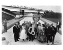
| Date: | 09 04 1958 |
|---|---|
| Description: | Dedication of Wisconsin's first expressway, a seven-mile stretch of Interstate Highway I-94 in Waukesha County, Wisconsin. Presiding at the ribbon-cutting ... |

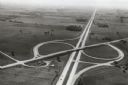
| Date: | 1954 |
|---|---|
| Description: | Elevated view of a newly opened divided four lane highway. |
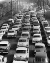
| Date: | 1957 |
|---|---|
| Description: | Elevated view of city traffic of bumper-to-bumper cars leaving Milwaukee County Stadium after the 1957 World Series. |

| Date: | 1965 |
|---|---|
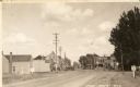
| Description: | Aerial view of town and Highway 66. |

| Date: | 1941 |
|---|---|
| Description: | Official highway map of Wisconsin, "the playground of the Midwest," showing the state transportation network prior to World War II. |

| Date: | 1960 |
|---|---|
| Description: | Aerial view of the construction of the interstate highway near Mirror Lake, showing only the early stages of the bridge construction. |
| Date: | 1967 |
|---|---|
| Description: | Intersection of US Highway 41 and Wisconsin Highway 26 near Oshkosh. |

| Date: | 1918 |
|---|---|
| Description: | "The playground of the Middle West." Showing the Numbered and Marked State Trunk Highway System and the Principal Secondary Highways; also locates Points o... |
| Date: | 02 1977 |
|---|---|
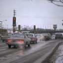
| Description: | Automobile exhaust on a cold February morning in Milwaukee. |

| Date: | 1913 |
|---|---|
| Description: | Wisconsin map showing fifteen hundred miles of national highways proposed by the National Highways Association. Scale: 1:2,500,000. These highways will dir... |

| Date: | 1969 |
|---|---|
| Description: | A man is driving a construction truck in the shadow cast by what appears to be an elevated highway. A sign for the "Brooklyn Battery Tunnel" is on one of t... |

| Date: | 1937 |
|---|---|
| Description: | Official state highway map, with insets of cities. |

| Date: | 1961 |
|---|---|
| Description: | View over beltline of University of Wisconsin-Madison Arboretum along Lake Wingra. Lake Mendota is on upper left, and Lake Monona is on the right, with the... |

| Date: | 1930 |
|---|---|
| Description: | Exterior view of the Triangle filling station on Highway 12, which sold gasoline, ice, and other items. A man stands in front by the gas pump, and a map of... |

| Date: | 09 26 1949 |
|---|---|
| Description: | A car drives down the western portion of the newly opened Madison belt line. The view is looking northwest in the region of Gilbert road (also Whitney Way)... |
| Date: | 11 11 1937 |
|---|---|
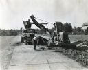
| Description: | A man shovels dirt from a highway five miles north of Richmond next to an Austin-Western Badger shovel powered by a McCormick-Deering engine. The equipmen... |

| Date: | 1977 |
|---|---|
| Description: | View looking north at the ramp from USH 41 northbound. |

| Date: | 1977 |
|---|---|
| Description: | A car going up ramp, northbound on USH 41. |
| Date: | |
|---|---|
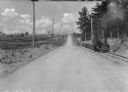
| Description: | View down center of a rural section of U.S. highway, with a small train running on railroad tracks alongside it. |
If you didn't find the material you searched for, our Library Reference Staff can help.
Call our reference desk at 608-264-6535 or email us at: