 Filter: Categories of Wisconsin Historical Images
Filter: Subject of Express highways
Filter: Subject of recreation
Filter: Categories of Wisconsin Historical Images
Filter: Subject of Express highways
Filter: Subject of recreation
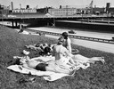
| Date: | 1965 |
|---|---|
| Description: | Women sun bathe near an express highway in Milwaukee. |

| Date: | 1975 |
|---|---|
| Description: | Aerial view of Milwaukee County Stadium and the intersection of US 41 and I-94. County Stadium was built in 1953 and demolished in 2001. Although undated... |
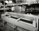
| Date: | 08 1948 |
|---|---|
| Description: | Exhibit in the Transportation Building at the Wisconsin Centennial Exposition, which included this model from the U.S. Public Roads Association. The model ... |

| Date: | 1969 |
|---|---|
| Description: | Advertising poster for International trucks and campers. Features a color photograph of a man and woman with a Travellall that is hooked to a camper; a pho... |
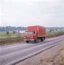
| Date: | 1972 |
|---|---|
| Description: | Color photograph of a man driving an International truck past a body of water in what appears to be a golf course. |
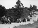
| Date: | 06 1982 |
|---|---|
| Description: | "Bill Zahn of Juneau organized this wagon train as it traveled on Y near Knowles." |
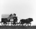
| Date: | 06 1982 |
|---|---|
| Description: | "Bill Zahn of Juneau organized this wagon train as it traveled on Y near Knowles." |

| Date: | 1936 |
|---|---|
| Description: | This 1936 Wisconsin Conservation Dept. map shows the locations of state forestry Civilian Conservation Corps (CCC) camps, closed state forestry CCC camps, ... |

| Date: | 1970 |
|---|---|
| Description: | A map showing highlighted snowmobile trails, ice crossings, and supporting businesses in the towns of Stephenson and Silver Cliff in Marinette County and ... |

| Date: | 1935 |
|---|---|
| Description: | This pictorial map of northern Bayfield County, Wisconsin, shows the Chequamegon National Forest, the Red Cliff Indian Reservation, highways and roads, and... |

| Date: | 1986 |
|---|---|
| Description: | This late 1980s map of Price County, Wisconsin, shows facilities and lands open for public recreation, hunter walking trails and ski trails, campgrounds, b... |

| Date: | 1987 |
|---|---|
| Description: | This 1987 map of Racine and Kenosha counties, Wisconsin, shows towns, sections, cities and villages, zip code boundaries, highways and roads, bicycle route... |
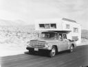
| Date: | 1960 |
|---|---|
| Description: | Man, woman, and a young child holding a pinwheel outside the window, are riding in an International 1966 Travelette pickup with camper attached. They are t... |

| Date: | 1962 |
|---|---|
| Description: | This map shows roads, golf courses, ski areas, boat landings, camp sites, waysides, parks, beaches, scenic views, virgin timber tracts, airports, boys and ... |

| Date: | 1940 |
|---|---|
| Description: | This pictorial map shows points of interest, recreation activities, and highways in the vicinity of the restaurant and covers the Wisconsin River Valley be... |

| Date: | 1980 |
|---|---|
| Description: | This map shows the locations of 42 businesses, roads, points of interest, recreation sites, camping, the North Country Trail and parking, and boundaries of... |

| Date: | 1960 |
|---|---|
| Description: | This map shows public boat ramps, parks, highways, beaches, bluffs, Green Bay, Garrett Bay, Europe Bay and Lake, Rowley's Bay and Ellison Bay. The map incl... |

| Date: | 1966 |
|---|---|
| Description: | This map includes a red overprint on base map and shows the supervisors and district numbers of St. Croix County. Includes diagrams of civil towns, townsh... |

| Date: | 1935 |
|---|---|
| Description: | This blue lined map shows the major roads and cities of Wisconsin. The map includes an index, hotel and cafe advertisements, as well as advertisements for ... |

| Date: | 1935 |
|---|---|
| Description: | This blue lined map ("compliments of Black Eagle Oil Company") shows the major roads and cities of Wisconsin. The map includes an index, hotel and cafe adv... |
If you didn't find the material you searched for, our Library Reference Staff can help.
Call our reference desk at 608-264-6535 or email us at: