 Filter: Categories of Wisconsin Historical Images
Filter: Subject of Express highways
Filter: Subject of cities and towns
Filter: Year of 1900-1999
Filter: Year of 1960-1969
Filter: Categories of Wisconsin Historical Images
Filter: Subject of Express highways
Filter: Subject of cities and towns
Filter: Year of 1900-1999
Filter: Year of 1960-1969
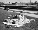
| Date: | 1965 |
|---|---|
| Description: | Women sun bathe near an express highway in Milwaukee. |

| Date: | 1965 |
|---|---|
| Description: | Aerial view of town and Highway 66. |

| Date: | 09 1962 |
|---|---|
| Description: | The Mississippi River along Highway 35. |

| Date: | 1965 |
|---|---|
| Description: | Aerial view of early construction at the Marquette Interchange in Milwaukee, the junction of Interstate Highways I94 and I43. Construction began in 1964, ... |
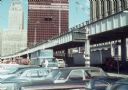
| Date: | 1969 |
|---|---|
| Description: | View of the construction of the World Trade Center from a nearby parking lot. |

| Date: | 1969 |
|---|---|
| Description: | A man is driving a construction truck in the shadow cast by what appears to be an elevated highway. A sign for the "Brooklyn Battery Tunnel" is on one of t... |

| Date: | 1961 |
|---|---|
| Description: | View over beltline of University of Wisconsin-Madison Arboretum along Lake Wingra. Lake Mendota is on upper left, and Lake Monona is on the right, with the... |
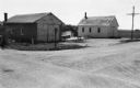
| Date: | 06 01 1966 |
|---|---|
| Description: | Highway County CTH "N" looking southeast. The white building on the right is the Marathon Town Hall. |

| Date: | 1962 |
|---|---|
| Description: | Cover of a brochure advertising International Fleetstar BBC Series 1900 and 2000 semi-trucks. The cover features the IHC logo and an illustration of a man ... |

| Date: | 1961 |
|---|---|
| Description: | An International DF 405 truck owned by Lucky Lager drives down a highway away. The Lucky Lager factory is in the background. |

| Date: | 1964 |
|---|---|
| Description: | Shows local streets, bus routes, highways, airport, Dells Pond, Half Moon Lake, Chippewa River, and Eau Claire River. Includes 2 inset maps: Location map a... |

| Date: | 1964 |
|---|---|
| Description: | Indexed map. Street names are to the left, map is to the right. Lakes, streets, highways, and points of interest are labelled. |

| Date: | 1960 |
|---|---|
| Description: | Color coded map in pink, yellow, blue, and brown of Milwaukee County State and County trunk highways. The map includes a legend of symbols: "STEAM RAIL ROA... |

| Date: | 1968 |
|---|---|
| Description: | This blue line print shows lot numbers and dimensions, existing or platted streets and highways, streets and highways to be widened, future streets, and vi... |

| Date: | 1961 |
|---|---|
| Description: | This street map includes an ancillary map of Dane County highways and a business directory. Lake Mendota, Lake Monona, Monona Bay, Yahara River, and Lake W... |

| Date: | 1968 |
|---|---|
| Description: | This blue line print map shows proposed changes reserving railroad right-of-ways for future highways, land plots, as well as Lake Monona and Lake Mendota. |

| Date: | 1962 |
|---|---|
| Description: | This map shows roads, golf courses, ski areas, boat landings, camp sites, waysides, parks, beaches, scenic views, virgin timber tracts, airports, boys and ... |

| Date: | 1960 |
|---|---|
| Description: | This map shows public boat ramps, parks, highways, beaches, bluffs, Green Bay, Garrett Bay, Europe Bay and Lake, Rowley's Bay and Ellison Bay. The map incl... |

| Date: | 1966 |
|---|---|
| Description: | This map includes a red overprint on base map and shows the supervisors and district numbers of St. Croix County. Includes diagrams of civil towns, townsh... |

| Date: | 1960 |
|---|---|
| Description: | This colored road map shows roads in Wisconsin as well as portions of nearby states. Information on the quality and type of any road shown can be found in ... |
If you didn't find the material you searched for, our Library Reference Staff can help.
Call our reference desk at 608-264-6535 or email us at: