 Filter: Categories of Wisconsin Historical Images
Filter: Subject of Express highways
Filter: Subject of church buildings
Filter: Categories of Wisconsin Historical Images
Filter: Subject of Express highways
Filter: Subject of church buildings

| Date: | 1926 |
|---|---|
| Description: | A topographic map of Green County, showing by contours and spot heights the topographic and natural features of the county. The contour intervals are 20 fe... |

| Date: | 1926 |
|---|---|
| Description: | A map of Lincoln County, Wisconsin that shows the township and range grid, towns, cities and villages, lakes and streams, residences, churches, school hous... |
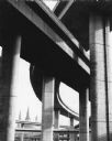
| Date: | 1971 |
|---|---|
| Description: | A view of the underside of a highway interchange. Steeples of a church are in the background. |
If you didn't find the material you searched for, our Library Reference Staff can help.
Call our reference desk at 608-264-6535 or email us at:
