 Filter: Categories of Wisconsin Historical Images
Filter: Subject of Express highways
Filter: Subject of boats and boating
Filter: Categories of Wisconsin Historical Images
Filter: Subject of Express highways
Filter: Subject of boats and boating
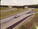
| Date: | 1965 |
|---|---|
| Description: | At many places in Wisconsin, the Interstate Highway is divided by a wide median strip that provides a scenic view for the motorist. This photograph shows ... |

| Date: | 1962 |
|---|---|
| Description: | This map shows roads, golf courses, ski areas, boat landings, camp sites, waysides, parks, beaches, scenic views, virgin timber tracts, airports, boys and ... |

| Date: | 1960 |
|---|---|
| Description: | This map shows public boat ramps, parks, highways, beaches, bluffs, Green Bay, Garrett Bay, Europe Bay and Lake, Rowley's Bay and Ellison Bay. The map incl... |

| Date: | 1935 |
|---|---|
| Description: | This colored road map comes with a map legend and explanation, as well as an index of cities and towns (and their populations) in Wisconsin. Information ab... |
If you didn't find the material you searched for, our Library Reference Staff can help.
Call our reference desk at 608-264-6535 or email us at: