 Filter: Categories of Wisconsin Historical Images
Filter: Subject of Express highways
Filter: Subject of associations, institutions, etc.
Filter: Categories of Wisconsin Historical Images
Filter: Subject of Express highways
Filter: Subject of associations, institutions, etc.
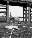
| Date: | 1974 |
|---|---|
| Description: | "The Lomira Legion building is framed in the arch of the Highway 67 overhead." |

| Date: | 1925 |
|---|---|
| Description: | This 1925 map of the northern portion of Sawyer County, Wisconsin, shows the township and range system, sections, roads, railroads, and lakes and streams i... |

| Date: | 1915 |
|---|---|
| Description: | Shows land ownership, roads, railroads, and highways. Includes significant manuscript annotations and table of Wisconsin Highway Commission members. "The r... |

| Date: | 1929 |
|---|---|
| Description: | This map of the entire state includes portions of Illinois, Iowa, Michigan, and Minnesota. The map shows U.S., state, and county highways, roads, campsites... |
If you didn't find the material you searched for, our Library Reference Staff can help.
Call our reference desk at 608-264-6535 or email us at: