 Filter: Categories of Wisconsin Historical Images
Filter: Subject of Express highways
Filter: Subject of advertising
Filter: Categories of Wisconsin Historical Images
Filter: Subject of Express highways
Filter: Subject of advertising
| Date: | |
|---|---|
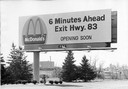
| Description: | A billboard advertising the opening of a particular McDonald's restaurant. Express highways promoted the emergence of large signs that could be read at a d... |
| Date: | 1965 |
|---|---|
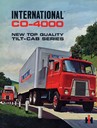
| Description: | Front cover of an advertising brochure for International CO-4000 trucks with the "new top quality tilt-cab." Cover features color illustration of two deliv... |

| Date: | 1969 |
|---|---|
| Description: | Advertising poster for International trucks and campers. Features a color photograph of a man and woman with a Travellall that is hooked to a camper; a pho... |

| Date: | 1962 |
|---|---|
| Description: | Cover of a brochure advertising International Fleetstar BBC Series 1900 and 2000 semi-trucks. The cover features the IHC logo and an illustration of a man ... |
| Date: | 1937 |
|---|---|
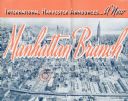
| Description: | Cover of a brochure celebrating a new International Harvester Manhattan branch, featuring an aerial photograph of Manhattan, including the corner of West 4... |

| Date: | 1923 |
|---|---|
| Description: | This map shows trails, some in red, for automobiles. The right margin includes a key of markings as well as Minnesota and Wisconsin Highway signs. Communit... |

| Date: | 1943 |
|---|---|
| Description: | Advertisement for International trucks featuring a color illustration of men working with an excavator and an International dump truck on the Alcan Highway... |

| Date: | 1931 |
|---|---|
| Description: | Page from an advertising brochure for International trucks. Two International trucks owned by the Ritter Bros. are parked on a highway construction site wh... |

| Date: | 1992 |
|---|---|
| Description: | This 1992 map of Wood County, Wisconsin, shows towns, sections, cities and villages, highways and roads, railroads, and lakes and streams. An inset map of ... |

| Date: | 1953 |
|---|---|
| Description: | This map shows local streets, roads, highways, Middleton, Monona, Lake Wingra, Lake Monona, Lake Mendota, and an inset map that shows city parking areas. A... |

| Date: | 1961 |
|---|---|
| Description: | This street map includes an ancillary map of Dane County highways and a business directory. Lake Mendota, Lake Monona, Monona Bay, Yahara River, and Lake W... |

| Date: | 1940 |
|---|---|
| Description: | This pictorial map shows points of interest, recreation activities, and highways in the vicinity of the restaurant and covers the Wisconsin River Valley be... |

| Date: | 1928 |
|---|---|
| Description: | A Wisconsin state highway map, featuring the major highways, rivers, lakes, and cities. There are a few advertisements on the front and back. The back also... |

| Date: | 1935 |
|---|---|
| Description: | This blue lined map shows the major roads and cities of Wisconsin. The map includes an index, hotel and cafe advertisements, as well as advertisements for ... |

| Date: | 1935 |
|---|---|
| Description: | This blue lined map ("compliments of Black Eagle Oil Company") shows the major roads and cities of Wisconsin. The map includes an index, hotel and cafe adv... |

| Date: | 1936 |
|---|---|
| Description: | This road map shows the major roads, cities, lakes, and rivers of Wisconsin and parts of the neighboring states and Canada, as well as advertisements for t... |

| Date: | 1975 |
|---|---|
| Description: | This map shows nature trails, public attractions, public hunting and fishing grounds, dams, waysides, lakes, highways, and roads. The upper right corner in... |

| Date: | 1937 |
|---|---|
| Description: | This map shows the major roads, cities, towns, lakes, and rivers of Wisconsin and some of the neighboring states. The front includes an add for Coca-Cola, ... |

| Date: | 1929 |
|---|---|
| Description: | This map of the entire state includes portions of Illinois, Iowa, Michigan, and Minnesota. The map shows U.S., state, and county highways, roads, campsites... |

| Date: | 1925 |
|---|---|
| Description: | The map shows the entire state with portions of Illinois, Iowa, Minnesota, and Michigan. The map shows concrete, gravel, all weather earth, clay, and sand ... |
If you didn't find the material you searched for, our Library Reference Staff can help.
Call our reference desk at 608-264-6535 or email us at: