Filter: Categories of Wisconsin Historical Images
Filter: Subject of Express highways
Filter: Reproduction Rights of For Sale
Filter: Categories of Wisconsin Historical Images
Filter: Subject of Express highways
Filter: Reproduction Rights of For Sale

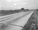
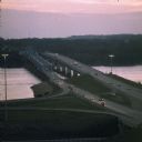
| Date: | 1954 |
|---|---|
| Description: | Elevated view of a newly opened divided four lane highway. |
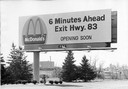
| Date: | |
|---|---|
| Description: | A billboard advertising the opening of a particular McDonald's restaurant. Express highways promoted the emergence of large signs that could be read at a d... |
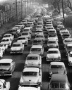
| Date: | 1957 |
|---|---|
| Description: | Elevated view of city traffic of bumper-to-bumper cars leaving Milwaukee County Stadium after the 1957 World Series. |
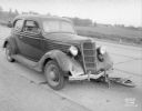
| Date: | 09 04 1938 |
|---|---|
| Description: | Accident scene on Highway 12-18 one-half mile east of the Dane County fairgrounds. Close-up of front of automobile, with bicycle under the car. Katherine B... |
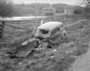
| Date: | 10 23 1937 |
|---|---|
| Description: | Close-up of damaged Chevrolet in a ditch next to Highway 12 near Highway KP & Roxbury, looking north, with a farmstead in the background. |
| Date: | 08 29 1933 |
|---|---|
| Description: | US Hwy 12 looking southwest, showing corn fields, McVicar Photo Service case, Sinclair sign and a good view of farm buildings in the background. |
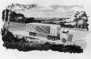
| Date: | 1964 |
|---|---|
| Description: | The tractor-trailer used to transport and display the world's largest cheese at the 1964 World's Fair held in New York. The 34,591 pound cheddar was made i... |

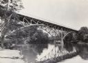
| Date: | 1930 |
|---|---|
| Description: | View of bridge and Brule River monument. Placed where the Brule River is crossed by the Memorial Highway from Superior to Brule and Ashland (Highway 2). |

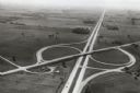
| Date: | 1998 |
|---|---|
| Description: | North-facing aerial view of the interchange between Interstates 39/90 and US Routes 12/18 in the southeast of Madison. Femrite Drive can be seen passing be... |
| Date: | 1960 |
|---|---|
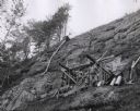
| Description: | View from below looking up towards workers constructing and reinforcing the forms for the footings of the interstate highway bridge at Mirror Lake. |

| Date: | 1960 |
|---|---|
| Description: | Aerial view of the construction of the interstate highway near Mirror Lake, showing only the early stages of the bridge construction. |
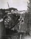
| Date: | 11 16 1960 |
|---|---|
| Description: | Elevated view of the interstate highway bridge construction at Mirror Lake showing the concrete footings halfway down the embankment. |
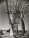
| Date: | 1961 |
|---|---|
| Description: | View taken from below of the Interstate Highway I-535 bridge during construction. |
| Date: | 1967 |
|---|---|
| Description: | Intersection of US Highway 41 and Wisconsin Highway 26 near Oshkosh. |

| Date: | 1979 |
|---|---|
| Description: | Aerial view of Interstate I-90/94 at Camp Douglas, looking northwest. |
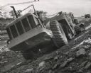
| Date: | 10 1959 |
|---|---|
| Description: | Construction of Interstate Highway I-94 in Waukesha County using an earthmover manufactured by Allis Chalmers. |

| Date: | 1918 |
|---|---|
| Description: | "The playground of the Middle West." Showing the Numbered and Marked State Trunk Highway System and the Principal Secondary Highways; also locates Points o... |
| Date: | 06 1977 |
|---|---|
| Description: | A view of the St. Croix River crossing at Hudson during the development of the Interstate Bridge. The old eastbound bridge seen here was built in 1951 whil... |
If you didn't find the material you searched for, our Library Reference Staff can help.
Call our reference desk at 608-264-6535 or email us at: