 Filter: Categories of Wisconsin Historical Images
Filter: Subject of Express highways
Filter: Creator Name of Unknown
Filter: Categories of Wisconsin Historical Images
Filter: Subject of Express highways
Filter: Creator Name of Unknown

| Date: | 1956 |
|---|---|
| Description: | Includes street index. Shows local streets, parks, highways, railroads, Fond du Lac River, and part of lake Winnebago. Also includes text on points of inte... |

| Date: | 1976 |
|---|---|
| Description: | Includes index of streets and of local businesses. Shows location of Citizens State Bank, roads, highways, railroads, parks, cemeteries, and city sanitary ... |

| Date: | 08 08 1973 |
|---|---|
| Description: | At a press conference northern representatives joined together to press their respective states to use newly appropriated funds to improve U.S. Highway 2 f... |

| Date: | 1952 |
|---|---|
| Description: | Map shows roads, highways, railroads, parks, city buildings, schools, cemeteries, city limits, and the Fox River. The map is indexed by street name, street... |
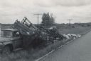
| Date: | 06 07 1966 |
|---|---|
| Description: | View from road of a truck pulled off to the side of the road. The back of the truck is collapsed, containing beehives spilling onto the ground. "E.R. Raley... |
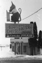
| Date: | 1986 |
|---|---|
| Description: | Warner Creek Cheese billboard, including a 3D sculpture of a mouse with cheese, in front of a small, brick building. Located off the State Highway near Hil... |

| Date: | 1953 |
|---|---|
| Description: | This map shows local streets, roads, highways, Middleton, Monona, Lake Wingra, Lake Monona, Lake Mendota, and an inset map that shows city parking areas. A... |

| Date: | 1933 |
|---|---|
| Description: | This blueprint map shows lakes, roads, railroads, townships and sections. A legend is also included that shows highway surface types. |

| Date: | 1966 |
|---|---|
| Description: | This map shows arterial roads. Original caption reads, "Approved July 7, 1996 by State Highway Commission of Wisconsin." Includes a symbol key in the lower... |

| Date: | 1975 |
|---|---|
| Description: | This map shows nature trails, public attractions, public hunting and fishing grounds, dams, waysides, lakes, highways, and roads. The upper right corner in... |

| Date: | |
|---|---|
| Description: | Photographic postcard view of a two-lane Interstate highway along railroad tracks. Two automobiles are moving down the road in the right lane, heading towa... |

| Date: | |
|---|---|
| Description: | View of a highway bridge spanning the Red Cedar River, and a road along the far shoreline. Caption reads: "U.S. Hy 12 New Bridge, Menomonie, Wis." |
If you didn't find the material you searched for, our Library Reference Staff can help.
Call our reference desk at 608-264-6535 or email us at: