 Filter: Categories of Wisconsin Historical Images
Filter: Subject of Europeans
Filter: Subject of water
Filter: Categories of Wisconsin Historical Images
Filter: Subject of Europeans
Filter: Subject of water

| Date: | 1655 |
|---|---|
| Description: | Christopher Columbus begins his first expedition, 1492. |

| Date: | 1655 |
|---|---|
| Description: | Encounter with Indians during Christopher Columbus' first expedition in 1492. |

| Date: | 1655 |
|---|---|
| Description: | Map from Drake Expedition, ca. 1585. |

| Date: | 1948 |
|---|---|
| Description: | Two preliminary watercolors of the right panel of the Centennial Mural in the Wisconsin Historical Society. The panel displays the history of Wisconsin ex... |

| Date: | 1948 |
|---|---|
| Description: | A watercolor of the right panel of the Centennial Mural in the Wisconsin Historical Society. This panel displays the history of Wisconsin exploration, mos... |

| Date: | 1957 |
|---|---|
| Description: | Large Letter style postcard for Green Bay depicting various scenes in the letters that spell the name of the city. Caption reads: "Greetings from Green Bay... |

| Date: | 1934 |
|---|---|
| Description: | Label submitted to the state of Wisconsin for trademark registration. Old Hollander beer, brewed by the Oconomowoc Brewing Company. On the label the beer i... |

| Date: | 04 1945 |
|---|---|
| Description: | A group of war correspondents, soldiers and officers pose outdoors on the sand in front of palm trees for a portrait in Guam. Many are holding a beverage a... |
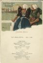
| Date: | 09 10 1908 |
|---|---|
| Description: | Dinner menu for the S.S. Marquette, with two women in traditional Dutch dresses and white caps, standing behind a fence and looking out at a ship at... |
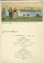
| Date: | 09 20 1908 |
|---|---|
| Description: | Luncheon menu from the S.S. Marquette, with women and a man in traditional Dutch clothing, standing or sitting on shore and looking out at a ship. ... |

| Date: | 1982 |
|---|---|
| Description: | This map shows the location of major settlement regions for various ethnic groups. Includes a legend in lower left hand corner. Sparse settlement is repres... |

| Date: | 1755 |
|---|---|
| Description: | Map of Virginia and parts of Maryland, North Carolina, and New Jersey. It shows borders, boundary lines, some Native American land, counties, cities, towns... |

| Date: | |
|---|---|
| Description: | Outdoor group portrait of men, women, and children. Title reads: "A bunch of natives, head of Lake Superior, Chippewas, Irish & Dutch." |
If you didn't find the material you searched for, our Library Reference Staff can help.
Call our reference desk at 608-264-6535 or email us at: