Filter: Categories of Wisconsin Historical Images
Filter: Subject of Engraving
Filter: Subject of rivers
Filter: Categories of Wisconsin Historical Images
Filter: Subject of Engraving
Filter: Subject of rivers
| Date: | 1856 |
|---|---|
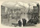
| Description: | View from bridge on river. Storefronts and homes line the road that stretches to the horizon. |
| Date: | 02 28 1863 |
|---|---|
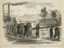
| Description: | The First Regiment of the Louisiana Native Guards disembarking at Fort Macomb, Louisiana. The fort is adjacent to the Venetian Isles community, now legally... |

| Date: | 1820 |
|---|---|
| Description: | Map of the Northwestern Territories of the United State showing the track pursued by the Expedition in 1820. |

| Date: | 1688 |
|---|---|
| Description: | This map includes vignettes of Amerindian life with text describing geography, culture, and exploration activity, written in French. The Great Lakes, river... |

| Date: | 1930 |
|---|---|
| Description: | Color illustration of the Rush Street Bridge and Chicago River as it appeared in 1861. Includes the C.H. McCormick Reaper Works on the far side of the rive... |
| Date: | 1887 |
|---|---|
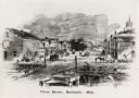
| Description: | Engraving of Pittsburg Landing taken from a photograph a few days after the Battle of Shiloh (Tennessee), which occurred on April 6-7, 1862. The image sho... |
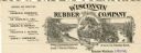
| Date: | |
|---|---|
| Description: | Letterhead of the Wisconsin Rubber Company of Madison, Wisconsin, which operated the Florida plantation in the state of Chiapas, Mexico. Includes an oval i... |
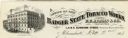
| Date: | |
|---|---|
| Description: | Letterhead of the Badger State Tobacco Works of Milwaukee, Wisconsin, with a three-quarter view of the building, men working on boats moored near the water... |
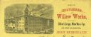
| Date: | |
|---|---|
| Description: | Letterhead of the Milwaukee Willow Works, a manufacturer of children's carriages, willow ware, and toys, with a three-quarter view of the company building,... |

| Date: | |
|---|---|
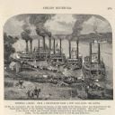
| Description: | Memohead of the Milwaukee Dry Dock Company, which operated two docks, with a view of a dock with ships, planks of wood, buildings, and the slogan, "Electri... |
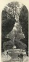
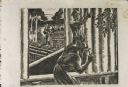
| Date: | 1874 |
|---|---|
| Description: | Engraved view of Rood's Glen. A boy plays with a toy boat at bottom left while two men and a woman talk at bottom right. Two other figures can be seen in t... |

| Date: | 1873 |
|---|---|
| Description: | Engraved image of a lock and dam at Sault St. Marie. Two men are operating the sluice as ships are waiting on the opposite side of the lock. Another man is... |

| Date: | 1831 |
|---|---|
| Description: | Map of the city of Louisville, Kentucky on the Ohio River showing streets and numbered lots. The Ohio River, Corn Island, and the Louisville and Portland C... |

| Date: | 1698 |
|---|---|
| Description: | An illustration of two men looking out at Niagara Falls. The Niagara Falls in Jean Louis Hennepin’s A new discovery of a vast country in America (London: M... |
| Date: | 1937 |
|---|---|
| Description: | Linoleum cut engraved view of men building a log cabin. One man carries a log in the background near a lake or river, while another man nails a log held in... |

| Date: | 1712 |
|---|---|
| Description: | Engraved double-hemispherical world map by Moll, included in his atlas The world described, or, A new and correct sett of maps: shewing the kingdoms and st... |

| Date: | 1696 |
|---|---|
| Description: | Engraved and hand-colored map of Ethiopia, from Blaeu's General Atlas. Map title is framed by a man and a woman, both wearing head turbans, who are standin... |

| Date: | 1798 |
|---|---|
| Description: | Engraved and hand-colored map of Egypt. Map title appears on bottom left as a carving in stone next ... |

| Date: | 1785 |
|---|---|
| Description: | Map of part of North America engraved and hand-colored (the light brown design is a superposition of the map and cartouche derived from the oxidation of th... |
If you didn't find the material you searched for, our Library Reference Staff can help.
Call our reference desk at 608-264-6535 or email us at: