Filter: Categories of Wisconsin Historical Images
Filter: Subject of Engraving
Filter: Subject of persons
Filter: Subject of international relations
Filter: Categories of Wisconsin Historical Images
Filter: Subject of Engraving
Filter: Subject of persons
Filter: Subject of international relations
| Date: | |
|---|---|
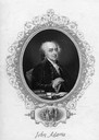
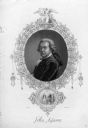
| Description: | Engraving by R.E. Babson of painting of John Adams by G. Stuart, with inset of "Talleyrand Receiving the American Envoys, 1797." |
| Date: | |
|---|---|
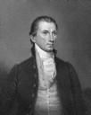
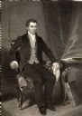
| Description: | Portrait engraving of James Monroe from a painting by J. Vanderlyn. |
| Date: | |
|---|---|
| Description: | Engraving of John Adams with an inset of "M. Tallyrand Receiving the American Envoys, 1797." |

| Date: | 1655 |
|---|---|
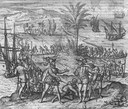
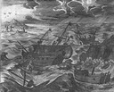
| Description: | Christopher Columbus begins his first expedition, 1492. |

| Date: | 1655 |
|---|---|
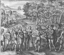
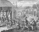
| Description: | Encounter with Indians during Christopher Columbus' first expedition in 1492. |
| Date: | 1655 |
|---|---|
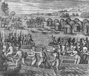
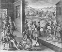
| Description: | Scene on Hispaniola in 1500, when Columbus was forced to return to Spain after a new adminstrator had arrived. |
| Date: | 1655 |
|---|---|
| Description: | Scene from the Vespucci Expedition, 1499. |
| Date: | 1655 |
|---|---|
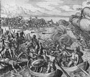
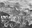
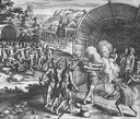
| Description: | Battle during the Vespucci Expedition, 1499. |
| Date: | 1655 |
|---|---|
| Description: | Scene from the Vespucci Expedition, 1499. |
| Date: | 1655 |
|---|---|
| Description: | Scene from Vespucci Expedition, 1499. |

| Date: | 1655 |
|---|---|
| Description: | Girolamo Benzoni (1519-1570) was an Italian from Milan who spent the years 1541-1556 in the New World. His observations of Spanish imperialism were publish... |
| Date: | 1655 |
|---|---|
| Description: | Scene from Laudonnière Expedition in Florida, ca. 1565. |
| Date: | 1655 |
|---|---|
| Description: | Scene from the Jamestown Settlement in Virginia, 1607. |
| Date: | 1655 |
|---|---|
| Description: | Scene from near Jamestown Settlement in Virginia, 1615. |
| Date: | 1861 |
|---|---|
| Description: | Portrait engraving of James Monroe from a painting by Alonzo Chappel. |

| Date: | 1715 |
|---|---|
| Description: | One of Herman Moll's most famous maps, often referred to as The Codfish Map, it shows rivers and portages, cities, Indian villages, wind directions, routes... |

| Date: | 1746 |
|---|---|
| Description: | Map of North America from the southern portion of James Bay to Florida. It shows the colonies, cities, Native American land, and topological and geographic... |

| Date: | 1758 |
|---|---|
| Description: | This map of the north-west hemisphere shows the cities, lakes, rivers, mountains, and political borders. In the upper left corner sits a decorative cartouc... |

| Date: | 1755 |
|---|---|
| Description: | This map shows the eastern half of North America during the French and Indian war, including cities, borders, Native American Land, forts, and detailed geo... |
If you didn't find the material you searched for, our Library Reference Staff can help.
Call our reference desk at 608-264-6535 or email us at: