Filter: Categories of Wisconsin Historical Images
Filter: Subject of Engraving
Filter: Subject of indians of north america
Filter: Subject of landforms
Filter: Categories of Wisconsin Historical Images
Filter: Subject of Engraving
Filter: Subject of indians of north america
Filter: Subject of landforms

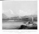
| Date: | 1832 |
|---|---|
| Description: | Junction of the Yellowstone River and the Missouri River. |
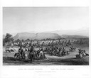
| Date: | 1832 |
|---|---|
| Description: | Camp of the Gros Ventres along the upper Missouri River, with white travelers passing by in a boat. |

| Date: | 1777 |
|---|---|
| Description: | This detailed map of the American colonies shows cities, villages, roads, mountains, lakes, rivers, swamps, counties, state boundaries, and Native American... |
If you didn't find the material you searched for, our Library Reference Staff can help.
Call our reference desk at 608-264-6535 or email us at: