Filter: Categories of Wisconsin Historical Images
Filter: Subject of Engraving
Filter: Subject of cities and towns
Filter: Subject of service industries
Filter: Categories of Wisconsin Historical Images
Filter: Subject of Engraving
Filter: Subject of cities and towns
Filter: Subject of service industries

| Date: | 1837 |
|---|---|
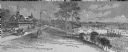
| Description: | Fond du Lac Company House, built in 1836 and operated as an inn by Colwert Pier and his wife. Groups of Indians are in the yard outside the inn, and severa... |
| Date: | 1860 |
|---|---|
| Description: | Elevated view of the Durkee House built by Charles Durkee in 1843. |

| Date: | 1885 |
|---|---|
| Description: | Elevated view of the Park Hotel, with city traffic in the streets in the foreground. "'Park Hotel' South Corner Capitol Park." The reverse side gives a des... |

| Date: | 1835 |
|---|---|
| Description: | Two-story home with sloping roof. One man is whipping a team of eight cattle while another man drives the plow behind them. To the left stands a man near a... |

| Date: | 01 09 1883 |
|---|---|
| Description: | A large crowd is on the street surrounding the burning building. Fire fighters are struggling with horses pulling the fire engine, and on the left a group... |
| Date: | 1891 |
|---|---|
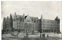
| Description: | Exterior view of the West Superior Hotel. There are pedestrians, a street car, and people riding in horse-drawn carriages on the street in front of the hot... |
| Date: | |
|---|---|
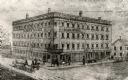
| Description: | Letterhead of Plankinton House in Milwaukee, Wisconsin, with a three-quarter view of the hotel and traffic in the street, including people on foot, on hors... |

| Date: | |
|---|---|
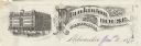
| Description: | Memohead of the Milwaukee Dry Dock Company, which operated two docks, with a view of a dock with ships, planks of wood, buildings, and the slogan, "Electri... |
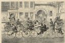
| Date: | 05 01 1869 |
|---|---|
| Description: | Humorous engraved image showing a street scene crowded with people riding bicycles. In the background are businesses identified as J. Shanks Livery Stable,... |

| Date: | 1720 |
|---|---|
| Description: | One of Herman Moll's most famous maps, often referred to as The Beaver Map for its elaborate engraved inset depicting and describing beavers building a dam... |

| Date: | 1767 |
|---|---|
| Description: | Map of the north east coast of America, showing colonial borders, cities, Native American land, lakes, rivers, and a few hills and mountains. Illustrated t... |

| Date: | 1780 |
|---|---|
| Description: | Detailed map of America east of the Louisiana region. It shows forts, cities, borders and boundary lines, Native American land, the post road, mountains, w... |
If you didn't find the material you searched for, our Library Reference Staff can help.
Call our reference desk at 608-264-6535 or email us at: