 Filter: Categories of Wisconsin Historical Images
Filter: Subject of Engraving
Filter: Subject of bridges
Filter: Creator Name of Unknown
Filter: Categories of Wisconsin Historical Images
Filter: Subject of Engraving
Filter: Subject of bridges
Filter: Creator Name of Unknown

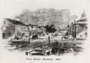
| Date: | 1856 |
|---|---|
| Description: | View along bridge of paddle boats and ships in the harbor, pedestrians, and the town in the background on the other side of the river. |
| Date: | 1856 |
|---|---|
| Description: | View from bridge on river. Storefronts and homes line the road that stretches to the horizon. |

| Date: | 1775 |
|---|---|
| Description: | Map of Boston and surrounding regions, from Massachusetts Bay to the Connecticut River, and including part of southern New Hampshire. It shows the colonies... |
If you didn't find the material you searched for, our Library Reference Staff can help.
Call our reference desk at 608-264-6535 or email us at: