Filter: Categories of Wisconsin Historical Images
Filter: Subject of Engraving
Filter: Subject of animals
Filter: Subject of children
Filter: Categories of Wisconsin Historical Images
Filter: Subject of Engraving
Filter: Subject of animals
Filter: Subject of children
| Date: | 1832 |
|---|---|
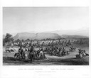
| Description: | Funeral of a Sioux Chief near Fort Pierre. |
| Date: | 1832 |
|---|---|
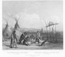
| Description: | A skin lodge of an Assiniboin Chief. The engraving includes a man on horseback and a dog harnessed to a travois. |

| Date: | 1857 |
|---|---|
| Description: | Bird's-eye view of Madison over rooftop and across lake with sailboats and steamers. A group of people are standing on a viewing platform on the roof in th... |
| Date: | 1893 |
|---|---|
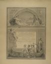
| Description: | Award certificate presented to the Appleton Woolen Mills at the 1893 Chicago World's Fair. The company won a bronze medal at the Fair for its paper makers... |
| Date: | 1855 |
|---|---|
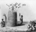
| Description: | An illustration of an Indian prophet standing by his lodge, which has symbols drawn on and floating above it. Others are seated, watching him. Two persons ... |
| Date: | 1884 |
|---|---|
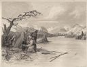
| Description: | Small group of Native Americans spearing fish through ice on a river. Mountains can be seen in the background. |
| Date: | 01 1869 |
|---|---|
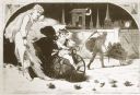
| Description: | Engraving after a drawing by Winslow Homer showing a crowned Baby New Year riding a velocipede through a hoop held by a woman, as the Grim Reaper, on the r... |

| Date: | 1696 |
|---|---|
| Description: | Engraved and hand-colored map of Ethiopia, from Blaeu's General Atlas. Map title is framed by a man and a woman, both wearing head turbans, who are standin... |

| Date: | 1746 |
|---|---|
| Description: | Map of North America from the southern portion of James Bay to Florida. It shows the colonies, cities, Native American land, and topological and geographic... |

| Date: | 1719 |
|---|---|
| Description: | Map of North America showing land divisions between France, Spain, England, Sweden, Denmark and Holland. The map is detailed, labeling cities, forts, islan... |
If you didn't find the material you searched for, our Library Reference Staff can help.
Call our reference desk at 608-264-6535 or email us at: