Filter: Categories of Wisconsin Historical Images
Filter: Subject of Engraving
Filter: Creator Name of Unknown
Filter: Subject of streets
Filter: Categories of Wisconsin Historical Images
Filter: Subject of Engraving
Filter: Creator Name of Unknown
Filter: Subject of streets
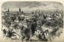
| Date: | 1874 |
|---|---|
| Description: | Bird's-eye view of Milwaukee looking southwest toward the county courthouse under construction in the public square west of St. John's Cathedral. |
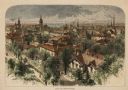
| Date: | 1860 |
|---|---|
| Description: | Elevated view of the Durkee House built by Charles Durkee in 1843. |

| Date: | 1910 |
|---|---|
| Description: | View of St. John's Evangelical Church in Monroe. |
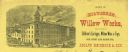
| Date: | |
|---|---|
| Description: | Letterhead of the Milwaukee Willow Works, a manufacturer of children's carriages, willow ware, and toys, with a three-quarter view of the company building,... |
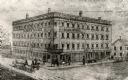
| Date: | |
|---|---|
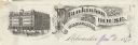
| Description: | Letterhead of Plankinton House in Milwaukee, Wisconsin, with a three-quarter view of the hotel and traffic in the street, including people on foot, on hors... |

| Date: | |
|---|---|
| Description: | Letterhead of the William Rahr Sons' Company of Manitowoc, Wisconsin, "Maltsters and Roasters," with an elevated view of the company building on one side o... |
| Date: | |
|---|---|
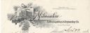
| Description: | Letterhead of the Milwaukee Lithographing & Engraving Company, with a three-quarter view of the building, set into a decorated border with the name of the ... |
| Date: | 1875 |
|---|---|
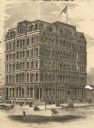
| Description: | Newspaper engraving of the building at Randolph and Dearborn Streets that served as the McCormick General Office from 1879 to 1885. An American flag flies ... |
| Date: | 12 1868 |
|---|---|
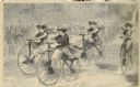
| Description: | Engraved view of four women racing on bicycles. Spectators in the background are behind a fence. |

| Date: | 1789 |
|---|---|
| Description: | Map of New York City showing ward boundaries, ferries, streets, roads, swamps, ponds, and rivers. The properties of Lispinard, Byards, Jones, Rutgers, and ... |

| Date: | 1776 |
|---|---|
| Description: | Fairly detailed map of New York City and parts of Long Island. It shows streets, roads, wharves, ferries, ship yards, Fort George and the battery, public b... |
If you didn't find the material you searched for, our Library Reference Staff can help.
Call our reference desk at 608-264-6535 or email us at: