 Filter: Categories of Wisconsin Historical Images
Filter: Subject of Engraving
Filter: Creator Name of Unknown
Filter: Subject of industries
Filter: Categories of Wisconsin Historical Images
Filter: Subject of Engraving
Filter: Creator Name of Unknown
Filter: Subject of industries
| Date: | |
|---|---|
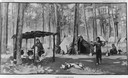
| Description: | Illustration of an Indian (possibly Menominee) camp of sugar makers. |
| Date: | 05 1866 |
|---|---|
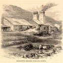
| Description: | Engraved exterior view of a smelting furnace with a small group of men with horses gathered in front. |
| Date: | 1853 |
|---|---|
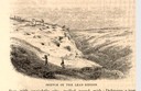
| Description: | Engraved view of miners and hillside mines in the Lead Region. Caption reads: "Sketch of the Lead Region." |
| Date: | 1853 |
|---|---|
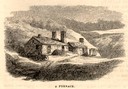
| Description: | Engraved exterior view of a lead mining furnace. A man sits in a horse-drawn wagon at the left of the building. |
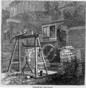
| Date: | 05 1866 |
|---|---|
| Description: | Engraved view of two men in a train locomotive observing the weighing of pig lead. Several bars of lead are stacked near the scale. |
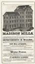
| Date: | 1851 |
|---|---|
| Description: | Engraving of the five-story tall mill erected at the outlet of the Yahara Creek by Leonard J. Farwell. This engraving appears in Statistics of Dane County,... |
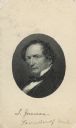
| Date: | |
|---|---|
| Description: | Carte-de-visite portrait engraving of Solomon Laurent Juneau (1793-1856), Wisconsin fur trader and politician. |
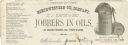
| Date: | |
|---|---|
| Description: | Letterhead of the Northwestern Oil Company of Milwaukee, Wisconsin, jobbers in various types of oils, with an engraving of a barrel of oil with a spigot ov... |

| Date: | |
|---|---|
| Description: | Memohead of the Milwaukee Dry Dock Company, which operated two docks, with a view of a dock with ships, planks of wood, buildings, and the slogan, "Electri... |

| Date: | 1782 |
|---|---|
| Description: | Map of the West Indies and south eastern North America, remarkably detailed, showing cities, mountains, rivers, lakes, mines, plantations, forts, banks, an... |

| Date: | 1800 |
|---|---|
| Description: | Map of the United States. It shows the states, including Tennessee, cities, towns, Native American land, mountains, lakes, and rivers. Lead mines appear ju... |

| Date: | 1720 |
|---|---|
| Description: | Map showing the course of the Mississippi River from the Gulf of Mexico up past Lake Superior into Canada. It shows the towns, Native American tribes and l... |
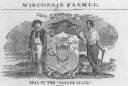
| Date: | 1857 |
|---|---|
| Description: | Great Seal of the State of Wisconsin as found in American Farmer, vol. 9. |
If you didn't find the material you searched for, our Library Reference Staff can help.
Call our reference desk at 608-264-6535 or email us at: