 Filter: Categories of Wisconsin Historical Images
Filter: Subject of Electric power
Filter: Subject of michigan, lake
Filter: Categories of Wisconsin Historical Images
Filter: Subject of Electric power
Filter: Subject of michigan, lake
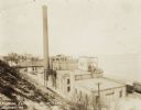
| Date: | 1927 |
|---|---|
| Description: | View from a hill looking down on the plant which has several attached buildings, and a large chimney. To the right are railroad cars along the shoreline o... |

| Date: | 1910 |
|---|---|
| Description: | This map shows railroads, counties, cities and villages, rivers, lakes, and electric lines are shown in Wisconsin, the western portion of Michigan's Upper ... |
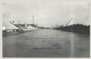
| Date: | 12 16 1957 |
|---|---|
| Description: | View across water, with cranes among piles of coal along the right, and among piles of other materials on the left. Smoke is in the distance on the right, ... |

| Date: | 01 09 1958 |
|---|---|
| Description: | View of Port Washington Harbor from Wisconsin Electric Power Company wharf. The city is in the background along the shoreline. |

| Date: | 1918 |
|---|---|
| Description: | This map shows counties, cities, towns, villages, summer resorts, lakes, rivers, creeks, wagon roads, roads, railroads, and electric lines. The authentic a... |
If you didn't find the material you searched for, our Library Reference Staff can help.
Call our reference desk at 608-264-6535 or email us at: