Filter: Categories of Wisconsin Historical Images
Filter: Subject of Electric power
Filter: Subject of land use
Filter: Categories of Wisconsin Historical Images
Filter: Subject of Electric power
Filter: Subject of land use
| Date: | 1924 |
|---|---|
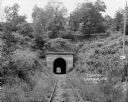
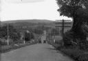
| Description: | View from railroad tracks through covered railroad tunnel in hill. A sign on a telephone pole on the right reads: "Private Property / Thoroughfare / Keep O... |
| Date: | 1925 |
|---|---|
| Description: | Railroad depot taken as part of a survey by the Wisconsin Power and Light Company to promote economic development by emphasizing available buildings and bu... |
| Date: | 1885 |
|---|---|
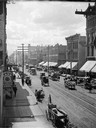
| Description: | Elevated view of West Water Street from Grand Avenue of horse-drawn vehicles, pedestrians, buildings, storefronts and power lines. |
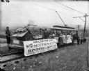
| Date: | 1899 |
|---|---|
| Description: | Group of people posing on a trolley car, which is pulling a flat car loaded with a McCormick grain binder and mower as part of an event culminating the "Cr... |
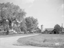
| Date: | 10 02 1945 |
|---|---|
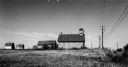
| Description: | Earl Sloan farm near Madison taken for the Wisconsin Power & Light Company. |
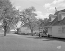
| Date: | 10 02 1945 |
|---|---|
| Description: | Ray Haupt farm near Madison, taken for Wisconsin Power & Light. |
| Date: | 10 02 1945 |
|---|---|
| Description: | William Siebert farm near Madison, taken for Wisconsin Power & Light Company. |
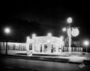
| Date: | 06 17 1930 |
|---|---|
| Description: | New Texaco Service Station at night, at 2846 Atwood Avenue. Owner Joseph M. Setzer. |
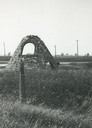
| Date: | 1920 |
|---|---|
| Description: | Charcoal kiln in ruins in a field beyond a fence, with electric power lines in the background. |
| Date: | 1905 |
|---|---|
| Description: | A lane in Ephraim with power lines lining the road. There is a body of water in the distance with houses on the far shoreline. |
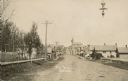
| Date: | 1910 |
|---|---|
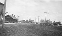
| Description: | View of Main Street when it was a dirt road. A church is in the background, and telephone poles are along the left side of the road. A streetlight is hangi... |

| Date: | 1918 |
|---|---|
| Description: | Intersection of Janesville Plan and North Cape Road, with telephone poles lining North Cape Road and cars parked on the side of Schunbrino's Saloon. |

| Date: | 1930 |
|---|---|
| Description: | Aerial view of Wisconsin Dells including the Wisconsin River and the dam and generating power plant. |
| Date: | 1917 |
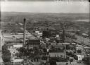
|---|---|
| Description: | View from Capitol dome east to Third Lake Ridge District. Power plant is visible at center. Lake Monona is on the right. |

| Date: | |
|---|---|
| Description: | Elevated view of cattle stockyards. Cattle can be seen in many different pens. |
| Date: | 1912 |
|---|---|
| Description: | View down hill toward two cars passing each other along the Lincoln Highway near Bedford, Pennsylvania. The Lincoln Highway was conceived in 1912 by Carl F... |
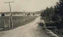
| Date: | 1964 |
|---|---|
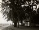
| Description: | A view to the horizon looking down Mineral Point Road, with a country house on the right under trees, during early evening hours. |
| Date: | 1954 |
|---|---|
| Description: | Exterior view of a reproduction of the world's first hydroelectric central station. It is located near the site of the original, which began operation on S... |
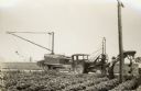
| Date: | 08 09 1927 |
|---|---|
| Description: | Men working along a road with a modified McCormick-Deering 10-20 industrial tractor with attached trailor and post hole digging rig. The men work for Shipp... |
If you didn't find the material you searched for, our Library Reference Staff can help.
Call our reference desk at 608-264-6535 or email us at: