 Filter: Categories of Wisconsin Historical Images
Filter: Subject of Electric power
Filter: Subject of lakes
Filter: Subject of cities and towns
Filter: Categories of Wisconsin Historical Images
Filter: Subject of Electric power
Filter: Subject of lakes
Filter: Subject of cities and towns
| Date: | 1959 |
|---|---|
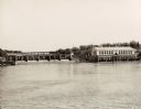
| Description: | The Kilbourn Hydroelectric Plant of the Wisconsin Power and Light Company. |
| Date: | 1917 |
|---|---|
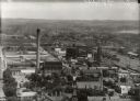
| Description: | View from Capitol dome east to Third Lake Ridge District. Power plant is visible at center. Lake Monona is on the right. |
| Date: | 1955 |
|---|---|
| Description: | Elevated view of the Milwaukee Road and Chicago & Northwestern Railway crossing on Monona Bay, the site of the old MX tower. |

| Date: | 1908 |
|---|---|
| Description: | A view of the Montello granite quarry with Montello Lake in the background. The sign in the foreground reads, "J.T. Barrett Pays Highest Prices for Furs, M... |
| Date: | 1910 |
|---|---|
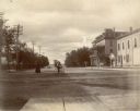
| Description: | A woman crosses Monona Avenue as a man on a bicycle rides by. The large, Second Empire style Avenue Hotel, with two-story porch, is on the left; the GAR ha... |

| Date: | 1905 |
|---|---|
| Description: | Forest Middleton, right, and a companion sit on the retaining wall along the north shore of Lake Monona near the steamboat dock. Two boats and the boathous... |
| Date: | 1905 |
|---|---|
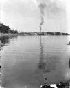
| Description: | A view east along the north shore of Lake Monona, with Madison's east side industrial area in the background. The Deering Harvester Company is identified b... |
| Date: | 1900 |
|---|---|
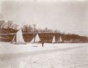
| Description: | Forest Middleton poses with his sled as his father, William, works with an iceboat behind him on frozen Lake Monona. There are other iceboats and boathouse... |
| Date: | 1905 |
|---|---|
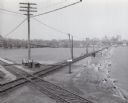
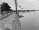
| Description: | A view east along the north shore of Lake Monona, with Madison's east side industrial area in the background. Tall utility poles and railroad tracks follow... |

| Date: | 1910 |
|---|---|
| Description: | This map shows railroads, counties, cities and villages, rivers, lakes, and electric lines are shown in Wisconsin, the western portion of Michigan's Upper ... |

| Date: | 1918 |
|---|---|
| Description: | This map shows counties, cities, towns, villages, summer resorts, lakes, rivers, creeks, wagon roads, roads, railroads, and electric lines. The authentic a... |

| Date: | 07 23 1946 |
|---|---|
| Description: | View across the street towards the Fauerbach Brewing Company, located at 651-653 Williamson Street. Automobiles are parked along the curb. On the left a tr... |
If you didn't find the material you searched for, our Library Reference Staff can help.
Call our reference desk at 608-264-6535 or email us at: