 Filter: Categories of Wisconsin Historical Images
Filter: Subject of Economics
Filter: Year of 1800-1899
Filter: Type of Map or Atlas
Filter: Categories of Wisconsin Historical Images
Filter: Subject of Economics
Filter: Year of 1800-1899
Filter: Type of Map or Atlas

| Date: | 1890 |
|---|---|
| Description: | Bird's-eye map of Beloit with insets of Williams Engine Works, Eclipse Wind Engine Co., and John Foster & Co. Turtle Creek is in the lower section, and the... |

| Date: | 1885 |
|---|---|
| Description: | Bird's-eye map of Waupun on the Rock River. There is an inset at top center of "Althouse, Wheeler & Co., Windmills and Pumps." |

| Date: | 1891 |
|---|---|
| Description: | Bird's-eye map of Stevens Point, looking east, with an inset of the Water Works. Wisconsin River in foreground with fifty-three business locations identifi... |

| Date: | 1896 |
|---|---|
| Description: | Bird's-eye view of Washburn, with twenty vignettes around side, water in foreground with docks and lumber corral. Thirty-three locations identified in key ... |

| Date: | 1890 |
|---|---|
| Description: | Bird's-eye view of Sheboygan on an advertisement for Kempf's Magical Salve, distributed by E.J. Kempf, "Legitimate Bill Poster and Distributor." |

| Date: | 1857 |
|---|---|
| Description: | A quarter section of a map of the city of Fond du Lac. This section features an illustration of Amory Hall and the Exchange Bank of Darling & Co. |

| Date: | 1898 |
|---|---|
| Description: | Shows railway lines in Wisconsin marked in red and counties in colors. The meridians are Greenwich, Wisconsin and Washington, Wisconsin. The map folds into... |

| Date: | 1874 |
|---|---|
| Description: | Map of New Diggings — inset map in bottom right corner of "Benton & New Diggings" map, on page 11 of "Atlas of Lafayette County Wisconsin," a collect... |

| Date: | 1878 |
|---|---|
| Description: | Map reads: "The P.P. Mast & Co's New Map of Wisconsin, Minnesota, and Northern Iowa". There are various advertisements for P.P. Mast & Co's broad-cast seed... |

| Date: | 1861 |
|---|---|
| Description: | Shows townships and sections, landowners, and woodlands. Includes inset maps of Monroe, Brodhead, Albany, Cadiz, Decatur, Dayton, Clarence, Springfield, Tw... |

| Date: | 1879 |
|---|---|
| Description: | A map of Jackson County, Wisconsin, shows the township and section survey, landownership, towns, villages, buildings, roads, railroads, county land, and st... |

| Date: | 1877 |
|---|---|
| Description: | A map of Monroe County, Wisconsin that shows the townships and landownership and acreage wagon roads, railroads, streams, schools, and houses. Also include... |

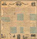
| Date: | 1876 |
|---|---|
| Description: | This 1876 map of Saint Croix County, Wisconsin, shows the township and range grid, sections, towns, cities and villages, land ownership and acreages, wagon... |
| Date: | 1886 |
|---|---|
| Description: | This 1886 map of Saint Croix County, Wisconsin, shows the township and range grid, sections, towns, cities and villages, land ownership and acreages, wagon... |

| Date: | 1877 |
|---|---|
| Description: | This 1877 map of Trempealeau County, Wisconsin, shows the township and range grid, sections, towns, cities and villages, land ownership and acreages, roads... |

| Date: | 1878 |
|---|---|
| Description: | This 1878 map of Vernon County, Wisconsin, shows the township and range grid, sections, towns, cities and villages, land ownership and acreages, roads, rai... |

| Date: | 1860 |
|---|---|
| Description: | This map of Dodge County, Wisconsin, shows the township and range grid, towns, sections, cities and villages, railroads, roads, property owners and acreage... |

| Date: | 1896 |
|---|---|
| Description: | This late 19th-century map of Dodge County, Wisconsin, shows the township and range grid, towns, sections, cities, villages and post offices, some property... |

| Date: | 1876 |
|---|---|
| Description: | Map shows landownership and acreages, roads and railroads, and some buildings. Includes illustrations of local buildings, business directories, and tables ... |

| Date: | 1873 |
|---|---|
| Description: | This 1873 map of Winnebago County, Wisconsin, shows the township and range grid, towns, sections, cities and villages, landownership and acreages, roads, r... |
If you didn't find the material you searched for, our Library Reference Staff can help.
Call our reference desk at 608-264-6535 or email us at: