 Filter: Categories of Wisconsin Historical Images
Filter: Subject of Economics
Filter: Subject of trails
Filter: Categories of Wisconsin Historical Images
Filter: Subject of Economics
Filter: Subject of trails
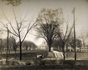
| Date: | 1909 |
|---|---|
| Description: | A billboard displays events at the foot of Bascom Hill from the bottom east side on the University of Wisconsin-Madison campus. Bascom Hall with dome (form... |

| Date: | 1938 |
|---|---|
| Description: | Cover of an advertising brochure for International Harvester "snow removal power." Features a picture of a undisturbed forest path covered in snow and the ... |

| Date: | 1920 |
|---|---|
| Description: | A pedestrian path along the Wisconsin River. An advertisement for J.M. Brophy general store is painted on the rock formations along the path. |

| Date: | 1970 |
|---|---|
| Description: | A map showing highlighted snowmobile trails, ice crossings, and supporting businesses in the towns of Stephenson and Silver Cliff in Marinette County and ... |
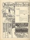
| Date: | 09 1895 |
|---|---|
| Description: | Full page, engraved advertisement for Andrae Cycles. Depicts men and women bicycling on a path in a bucolic setting, in addition to text promoting bicycles... |

| Date: | 1836 |
|---|---|
| Description: | This map shows settlers houses and businesses, trails, and swamps. The relief is shown by hachures. The map includes illustrations of historical buildings ... |

| Date: | 1860 |
|---|---|
| Description: | This map shows roads, trails, and railroads throughout Nebraska, Arkansas, Missouri, Kansas, Illinois, and Utah, including the Salt Lake City & California ... |

| Date: | 2006 |
|---|---|
| Description: | This map includes indexed advertisements and map of the Lac du Flambeau region on back. The map is broken into 9 zones, each marked with state and club tra... |

| Date: | 1990 |
|---|---|
| Description: | This map shows various types of trails, boat landings, canoe areas, public beaches, picnic areas, campgrounds, golf courses, public tennis courts, and othe... |

| Date: | 1980 |
|---|---|
| Description: | This map shows the locations of 42 businesses, roads, points of interest, recreation sites, camping, the North Country Trail and parking, and boundaries of... |

| Date: | 1975 |
|---|---|
| Description: | This map shows nature trails, public attractions, public hunting and fishing grounds, dams, waysides, lakes, highways, and roads. The upper right corner in... |

| Date: | 1943 |
|---|---|
| Description: | This map shows roads, trails, taverns, schools, golf, gas stations, campsites, resorts, and towers. The lower left of the map includes a legend. The map co... |

| Date: | 1991 |
|---|---|
| Description: | This map shows public access, fish crib locations, resorts, and other local businesses as well as advertisements for local attractions and a resort index. ... |
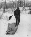
| Date: | 1976 |
|---|---|
| Description: | Elderly man pulling a sled loaded with packages and bags. He is wearing a plaid coat. His dog is sniffing the snow. Trees cover a snow covered berm in the ... |
If you didn't find the material you searched for, our Library Reference Staff can help.
Call our reference desk at 608-264-6535 or email us at: