 Filter: Categories of Wisconsin Historical Images
Filter: Subject of Economics
Filter: Subject of parking facilities
Filter: Categories of Wisconsin Historical Images
Filter: Subject of Economics
Filter: Subject of parking facilities
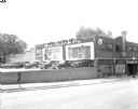
| Date: | 06 20 1944 |
|---|---|
| Description: | Ace Buick Company sales and service garage, 16 N. Fairchild Street, with Gardner's Purity Bread and Coca-Cola billboards on the side of the building. Autom... |

| Date: | 07 21 1962 |
|---|---|
| Description: | A parking lot underneath a newly developed block of stores. The Rock River is visible just beyond the parking lot. There is a bridge in the background. |

| Date: | 12 1980 |
|---|---|
| Description: | A large shadow from a cement wall is cast over the parking lot to Clark Gas Station at 2422 West Capitol Drive. A billboard for Coronet VSQ Brandy is mount... |
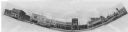
| Date: | 06 1967 |
|---|---|
| Description: | Composite panoramic view of the south side of the 300 block of State Street. Businesses include: Montgomery Ward (on North Henry Street), Colonial Shoppe E... |

| Date: | 1955 |
|---|---|
| Description: | Bottom of the map reads: "PARKING AREA STUDY MILWAUKEE COUNTY ZOOLOGICAL GARDEN SCALE 1"=200" APRIL 21, 1955 TOTAL PARKING AREA - 3736 CARS 31.1 acres". Th... |

| Date: | 1959 |
|---|---|
| Description: | Aerial view of the Westgate Shopping Center under construction. |
If you didn't find the material you searched for, our Library Reference Staff can help.
Call our reference desk at 608-264-6535 or email us at:
