 Filter: Categories of Wisconsin Historical Images
Filter: Subject of Economics
Filter: County of Walworth
Filter: Categories of Wisconsin Historical Images
Filter: Subject of Economics
Filter: County of Walworth
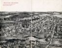
| Date: | 1909 |
|---|---|
| Description: | Illustration of town. Caption reads: "Bird's-eye View, Lyons, Wisconsin. A Village of natural environments, choice residence locations, desirable factory s... |
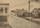
| Date: | 1861 |
|---|---|
| Description: | Moulding Mill on First Street of Whitewater, Wisconsin, the building on the left is the bank. |
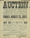
| Date: | 1883 |
|---|---|
| Description: | Broadside advertising an auction at the L.P. Bailey farm near Delavan. Sale included cattle, horses and hogs. |

| Date: | 10 07 1905 |
|---|---|
| Description: | Interior view of the Genoa Junction Free Public Library. Reverse of cardboard mounting reads: "Genoa Junction Free Public Library, Genoa Junction, Wisconsi... |
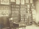
| Date: | 10 07 1905 |
|---|---|
| Description: | Interior view of the Genoa Junction Free Public Library. Reverse of cardboard mounting reads: "Genoa Junction Free Public Library, Genoa Junction, Wisconsi... |

| Date: | 1926 |
|---|---|
| Description: | This old hotel was known variously as the Park, Brick, or Circus hotel and dates from the 1870s. The large brick structure has a front gable with fancy shi... |
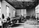
| Date: | |
|---|---|
| Description: | Printing presses are towards the back of the long, narrow room, and in the foreground are tables with type laid out in form or frame for letterpress printi... |
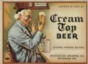
| Date: | 1938 |
|---|---|
| Description: | Label submitted to the state of Wisconsin for trademark registration. "Cream Top Beer, Whitewater Brewing Co." Pictured on the label is a man sitting at a ... |

| Date: | 1966 |
|---|---|
| Description: | This 1966 map shows topography, roads, highways, golf courses, government buildings, and businesses around Delavan Lake in Walworth County, Wisconsin. Incl... |

| Date: | 1900 |
|---|---|
| Description: | Pen and pencil on tracing paper. Shows landownership by name, local streets, local businesses, mill pond, creek, and proposed railroad. |
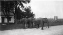
| Date: | 1920 |
|---|---|
| Description: | Three elephants on the side of the road near Holloway Farm. Two of the elephants are chained together. They may have been circus animals going from one tow... |
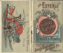
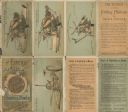
| Date: | 1902 |
|---|---|
| Description: | Front and back of 8-page foldout color brochure. Front cover advertises the "All Steel Folding Platform Binder & Mower." Back cover features a horizontal i... |
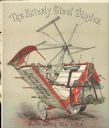
| Date: | 1902 |
|---|---|
| Description: | Inside half-page spread of foldout brochure. Features an illustration of the Esterly Enclosed Gear Mower showing Raising Device. Includes an inset on botto... |
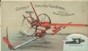
| Date: | 1902 |
|---|---|
| Description: | Full-size inside spread of foldout brochure. Features an illustration of the Esterly Steel Binder. Includes the phrase: "Folding platform / no trucks requi... |
| Date: | 1902 |
|---|---|
| Description: | Front of 8-page foldout brochure. Includes 4 illustrations of machinery, including the Esterly Steel Binder, Canvas Bundle Carrier, Folding Platform or Tru... |

| Date: | 1858 |
|---|---|
| Description: | This map is hand-colored and mounted on cloth and shows lot and block numbers and dimensions, landownership, streets, railroads, selected buildings, fair g... |

| Date: | 1962 |
|---|---|
| Description: | This blue print map shows 5 zoning districts, as well as lot and block numbers and dimensions, public land, streets, and Mill Pond. The zones are: "Single ... |

| Date: | 1857 |
|---|---|
| Description: | This map shows roads, railroads, lakes, and land ownership by name. Also included are illustrations of select business and residences, business directories... |

| Date: | 1937 |
|---|---|
| Description: | This cadastral map shows lots, streets, and Pell Lake. The back of the map includes a large advertisement for the Pell Lake Addition summer home lots. |
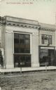
| Date: | |
|---|---|
| Description: | Photographic view from unpaved street of the facade of Citizens' Bank. A confectionery and a dentist's office are next door on the right. Caption reads: "T... |
If you didn't find the material you searched for, our Library Reference Staff can help.
Call our reference desk at 608-264-6535 or email us at: