 Filter: Categories of Wisconsin Historical Images
Filter: Subject of Economics
Filter: County of Polk
Filter: Categories of Wisconsin Historical Images
Filter: Subject of Economics
Filter: County of Polk

| Date: | |
|---|---|
| Description: | This map from the early 20th century shows the township and range grid, towns, sections, cities and villages, railroads, roads, schools, churches, and stre... |
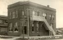
| Date: | |
|---|---|
| Description: | Exterior view from street of the State Bank with a corner entrance. The brick building has two-stories, with a set of wooden stairs on one side leading up ... |
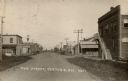
| Date: | 1920 |
|---|---|
| Description: | View down center of Main Street. The State Bank is in the foreground on the right. A hardware store and hotel are on the left. There is a windmill in the d... |
If you didn't find the material you searched for, our Library Reference Staff can help.
Call our reference desk at 608-264-6535 or email us at: