Filter: Categories of Wisconsin Historical Images
Filter: Subject of Economics
Filter: County of Bayfield
Filter: Categories of Wisconsin Historical Images
Filter: Subject of Economics
Filter: County of Bayfield
| Date: | |
|---|---|
| Description: | View of exterior of the Cable Drug Store. The signs on the exterior advertise that they have a soda fountain with Russell's Ice Cream and Coca-Cola. |
| Date: | 1969 |
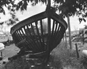
|---|---|
| Description: | Looking through the ribs of the hull of a boat under construction in a boatyard. |

| Date: | 1896 |
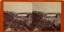
|---|---|
| Description: | Bird's-eye view of Washburn, with twenty vignettes around side, water in foreground with docks and lumber corral. Thirty-three locations identified in key ... |
| Date: | 1904 |
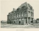
|---|---|
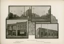
| Description: | Composite photograph of four views of Washburn, including Main Street, looking West, Bayfield County Bank, Main Street, looking East, and Northern State Ba... |
| Date: | 1936 |
|---|---|
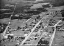
| Description: | Aerial view of Cable, in northern Wisconsin. Text at foot reads: "Airplane View of Cable, Wis. 244." |
| Date: | 1935 |
|---|---|
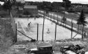
| Description: | View from above of spectators watching men play doubles tennis at a downtown tennis court. There is a water tower in the background. |

| Date: | 1931 |
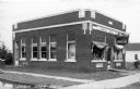
|---|---|
| Description: | Exterior view of a one-story brick building with a brick chimney, the Mason State Bank. An automobile is parked nearby, and in the background are other bui... |
| Date: | 1932 |
|---|---|
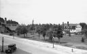
| Description: | Elevated view of one automobile parked on Main Street near a park (the Legion Memorial Park), trees, an American flag, street lights, and various buildings... |

| Date: | 1932 |
|---|---|
| Description: | Elevated view of one automobile parked on Main Street. The Legion Memorial Park is across the street. There is a hospital building in the background. Trees... |
| Date: | 1930 |
|---|---|
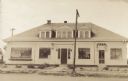
| Description: | Exterior view of the front facade of a building. The left side has a sign that says: "State Bank of Drummond" and the window on the right says: "Soda and I... |

| Date: | 1990 |
|---|---|
| Description: | This map shows various types of trails, boat landings, canoe areas, public beaches, picnic areas, campgrounds, golf courses, public tennis courts, and othe... |
| Date: | 1990 |
|---|---|
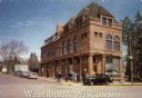
| Description: | Text on front reads: "Washburn, Wisconsin." On reverse: "Washburn Historical Museum and Cultural Center. National Register of Historical Places. Washburn, ... |

| Date: | 09 1918 |
|---|---|
| Description: | An insurance map of Washburn, with an index and a key. Includes a small inset map of the State of Wisconsin that shows "Location of this town as above unde... |
If you didn't find the material you searched for, our Library Reference Staff can help.
Call our reference desk at 608-264-6535 or email us at: