 Filter: Categories of Wisconsin Historical Images
Filter: Subject of Dwellings
Filter: Subject of trees
Filter: Year of 2000-Present
Filter: Categories of Wisconsin Historical Images
Filter: Subject of Dwellings
Filter: Subject of trees
Filter: Year of 2000-Present

| Date: | 2007 |
|---|---|
| Description: | This map of Cedarbug is a bird's-eye map with 8 inset views and an index. The map is a print out of the original map dated 1892 held at the Cedarburg Cultu... |
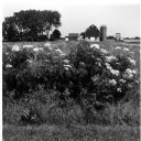
| Date: | 2001 |
|---|---|
| Description: | Elderberries in the countryside foreground and a landscape view of the Quinney farm. |
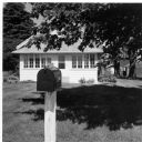
| Date: | 2001 |
|---|---|
| Description: | Mailbox and front porch of the Quinney farmhouse. |
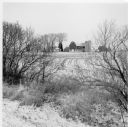
| Date: | 2001 |
|---|---|
| Description: | Winter scene of a snow-covered landscape near the Quinney farm. |
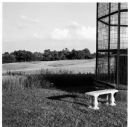
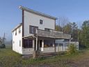
| Date: | 2003 |
|---|---|
| Description: | A landscape view toward the Old Place on the Quinney farm. |
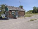
| Date: | 2008 |
|---|---|
| Description: | Knute Bjornson originally built this house in the 1860's and in 1933, his grandson Cooney Bjornson reassembled the humble log building to house a gas stati... |
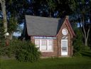
| Date: | 2008 |
|---|---|
| Description: | The brick building at 340 South Chestnut Street, was built around 1930. It resembled the house-with-canopy-type station commonly constructed throughout the... |
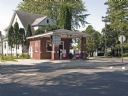
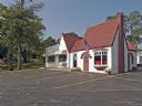
| Date: | 2008 |
|---|---|
| Description: | Constructed of red brick and capped by a steeply pitched gable roof accented with gently flared eaves, this one-story station, built in the mid-1920s, rese... |
| Date: | 2008 |
|---|---|
| Description: | Located at 252-256 West Capitol Drive, this Tudor Revival-style structure was built as a residence in the early 1920s and was altered a few years later by ... |
| Date: | 2008 |
|---|---|
| Description: | Located at 100 South Jefferson Street, started out as a Phillips 66 service station, built in 1935. It is currently Uncle Harry's Frozen Custard. |
| Date: | 2008 |
|---|---|
| Description: | Rudy Kuchlenz built this clapboard-sided building at the crossroads of U.S. Highway 8 and County Highway J in the village of Kennan, in 1927. |

| Date: | 2004 |
|---|---|
| Description: | View from across street of a man holding Bush-Cheney '04 sign along intersection. A man next to him holds an illegible sign. |
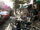
| Date: | 2009 |
|---|---|
| Description: | Customers around outside seating at Jule's Coffee shop on Pearl Street. |
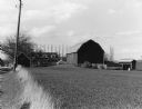
| Date: | 2004 |
|---|---|
| Description: | This is the Boeck Farm from down the road a bit. |
| Date: | 2004 |
|---|---|
| Description: | Andy and Karen Schnitzler, owner/operator of the River View Hills and Apartments, 100 Kelly Boulevard, use this barn for their Community Center. |
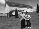
| Date: | 2004 |
|---|---|
| Description: | Leo and Helen Bonack, at W2472 Hwy TW (Section 6), have lived here for 38 years. Cows were last milked in 1960. |
| Date: | 11 16 2001 |
|---|---|
| Description: | "On this evening we travel to American Legion, Bonau Whereatt, Post 69 in Mayville, WI. Carl "Bear" Bandle is the manager." Note the fish fry signboard. |
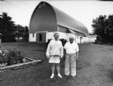
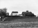
| Date: | 2004 |
|---|---|
| Description: | The Arnold and Bernice Lifke farm is located on a high hill at W1749 McArthur Road (Section 20). |
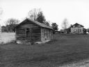
| Date: | 2004 |
|---|---|
| Description: | This old one-room schoolhouse is on the Priestaf property. Called the "Good Road School," it was closed in the 1950s. The Priestaf house is a log building. |
| Date: | 2004 |
|---|---|
| Description: | The Mork property is landlocked. Laura has to drive on a neighbors property to reach Hwy 175. |
If you didn't find the material you searched for, our Library Reference Staff can help.
Call our reference desk at 608-264-6535 or email us at: