 Filter: Categories of Wisconsin Historical Images
Filter: Subject of Dwellings
Filter: Subject of trees
Filter: Subject of human settlements
Filter: Categories of Wisconsin Historical Images
Filter: Subject of Dwellings
Filter: Subject of trees
Filter: Subject of human settlements
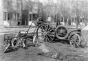
| Date: | 1917 |
|---|---|
| Description: | Man using a Mogul 10-20(?) tractor with attached plow to plow garden lots in an urban residential neighborhood at Jackson Blvd. and 54th Street. "This outf... |

| Date: | 1852 |
|---|---|
| Description: | Pencil drawing of Madison landscape as seen from University Hill. The main street in the center is State Street, and the building with Greek columns in the... |

| Date: | 1910 |
|---|---|
| Description: | Exterior of ice cream parlor with a horse-drawn wagon parked on the right with sheds behind. Barrels are stacked on the porch. Signs above the porch read: ... |
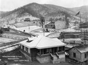
| Date: | 11 28 1922 |
|---|---|
| Description: | Newly constructed doctor's office. Benham was a "company town" created by International Harvester for the workers employed in the mines of its subsidiary, ... |
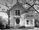
| Date: | 05 15 1960 |
|---|---|
| Description: | Exterior of a house with a keyhole shaped window. |
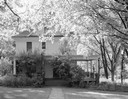
| Date: | 08 11 1960 |
|---|---|
| Description: | Exterior of a house surrounded by backlit trees. |
| Date: | 01 06 1919 |
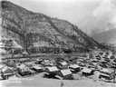
|---|---|
| Description: | Residential neighborhood. Caption reads: "Building Site East". Benham was a "company town" created by International Harvester for the workers employed in t... |

| Date: | 1885 |
|---|---|
| Description: | Bird's-eye map of Oconomowoc. |

| Date: | 1882 |
|---|---|
| Description: | Bird's-eye map of Lake Geneva, looking southwest, with insets of points of interest. |

| Date: | 2007 |
|---|---|
| Description: | This map of Cedarbug is a bird's-eye map with 8 inset views and an index. The map is a print out of the original map dated 1892 held at the Cedarburg Cultu... |

| Date: | 1878 |
|---|---|
| Description: | Bird's-eye map of Chilton with insets of points of interest, including P.H. Becker's Brewery, Chilton House, and Gutheil's Block. |

| Date: | 1874 |
|---|---|
| Description: | Bird's-eye map of Chippewa Falls. |

| Date: | 1891 |
|---|---|
| Description: | Bird's-eye view of Eau Claire. |

| Date: | 1880 |
|---|---|
| Description: | Bird's-eye map over the Mississippi River of Fountain City. Paddle steamers and steamboats are on the river, and bluffs are in the background. |

| Date: | 1877 |
|---|---|
| Description: | Bird's-eye map of Janesville on the Rock River. |

| Date: | 1893 |
|---|---|
| Description: | Bird's-eye map of Jefferson, looking north. Crayfish River at left and center, Rock River from upper center to bottom center, joins at left of center; thir... |

| Date: | 12 21 1882 |
|---|---|
| Description: | Bird's-eye map of Kaukauna, from the Appleton Post Annual Review. |

| Date: | 1881 |
|---|---|
| Description: | Bird's-eye map of Milton Junction. |
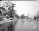
| Date: | 01 09 1946 |
|---|---|
| Description: | Winnebago Street from the Yahara River Bridge, scene of accident, near railroad crossing. There is a Victorian house at left, 1628 Winnebago Street, with a... |
If you didn't find the material you searched for, our Library Reference Staff can help.
Call our reference desk at 608-264-6535 or email us at:
