 Filter: Categories of Wisconsin Historical Images
Filter: Subject of Dwellings
Filter: Type of Map or Atlas
Filter: Categories of Wisconsin Historical Images
Filter: Subject of Dwellings
Filter: Type of Map or Atlas

| Date: | 1862 |
|---|---|
| Description: | This detailed map shows batteries and rifle pits, railroads, common and military roads, turnpikes, city streets and names, bridges, ferries, rural houses a... |

| Date: | 1962 |
|---|---|
| Description: | A map showing the location of Indian settlements in Wisconsin, indicating the settlements of the Chippewa, or Ojibwe, at St. Croix, Lac Courte Oreilles, Re... |

| Date: | 1931 |
|---|---|
| Description: | This U.S. Geological Survey map of Wisconsin shows counties, cities and villages, lighthouses, Indian reservations, military reservations, and bird and gam... |

| Date: | 09 1884 |
|---|---|
| Description: | Sanborn map of Fort Atkinson including Barrie, Germany, and North Water Streets. |

| Date: | 09 1884 |
|---|---|
| Description: | Sanborn map of Fort Atkinson including South Water and Milwaukee Streets. |

| Date: | 1868 |
|---|---|
| Description: | A detailed, cloth mounted map of Grant County that shows the townships, towns, roads, completed and under construction railroads, cemeteries, mills, lead m... |

| Date: | 1926 |
|---|---|
| Description: | A topographic map of Green County, showing by contours and spot heights the topographic and natural features of the county. The contour intervals are 20 fe... |
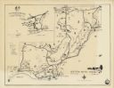
| Date: | |
|---|---|
| Description: | A map of the Northern Baptist Assembly estate on the shore of Green Lake, Green Lake County, Wisconsin shows roads, buildings, and private homes. An inset ... |

| Date: | 1870 |
|---|---|
| Description: | A map of Iowa County, Wisconsin mounted on cloth that shows the villages of Avoca, Mifflin, Linden, Arena, Helena Station, Highland, Dodgeville, as well as... |

| Date: | 1898 |
|---|---|
| Description: | A map of Iron County, Wisconsin, shows vacant Wisconsin Central Rail Road lands, settlers houses, land sold by Wisconsin Central R.R., schools, churches, s... |

| Date: | |
|---|---|
| Description: | A brochure and map of Jefferson County, Wisconsin, which includes color illustrations, a highway map of the county, a location map, and descriptions of poi... |

| Date: | 1899 |
|---|---|
| Description: | Overhead map of the Stanley McCormick's Riven Rock estate in El Montecito, Santa Barbara, California. The map shows the placement of dwellings and fields, ... |

| Date: | 1941 |
|---|---|
| Description: | A pictorial map of Lake Mendota that shows Indian sites and legends associated with the Lake and its surrounding area. Some of those mentioned on the map i... |

| Date: | 1993 |
|---|---|
| Description: | A series of three maps showing the lands of the Menominee, the first of these three maps shows the present-day Menominee Indian Reservation. Highways and r... |

| Date: | 1877 |
|---|---|
| Description: | A map of Monroe County, Wisconsin that shows the townships and landownership and acreage wagon roads, railroads, streams, schools, and houses. Also include... |

| Date: | 1882 |
|---|---|
| Description: | This manuscript map from 1882 shows land use and land for sale in a portion of the Town of Pewaukee, Waukesha County, Wisconsin. Woods, marshland, springs,... |

| Date: | 1887 |
|---|---|
| Description: | This 1887 map of Price County, Wisconsin, shows the township and range system, sections, railroads, vacant land and land sold by the Wisconsin Central Rail... |

| Date: | 1888 |
|---|---|
| Description: | This late 19th century map of Price County, Wisconsin, shows landownership and waterfront acreages, the township and range system, towns, cities and villag... |
If you didn't find the material you searched for, our Library Reference Staff can help.
Call our reference desk at 608-264-6535 or email us at:

