 Filter: Categories of Wisconsin Historical Images
Filter: Subject of Dwellings
Filter: Type of Map or Atlas
Filter: Categories of Wisconsin Historical Images
Filter: Subject of Dwellings
Filter: Type of Map or Atlas
| Date: | 1912 |
|---|---|
| Description: | Map shows roads, railroads, post offices, schools, houses, churches, routes, and post office collection boxes. The map includes a distant chart and explana... |

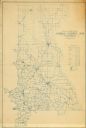
| Date: | 1857 |
|---|---|
| Description: | Map of La Crosse County, Wisconsin showing village plat, farm houses, schools, roads, railroads, township names (New Amsterdam, Dacota, Minnesota, Driesbac... |

| Date: | 1910 |
|---|---|
| Description: | Map is a blueline print. Map shows United States postal routes for La Crosse County. A list of stations include: Bangor R R 1-3, Holmen R R 1-2, La Crosse ... |

| Date: | 1940 |
|---|---|
| Description: | This map of Aztalan is pencil and ink on paper. The map shows streets, local businesses, churches, houses, and the Crawfish River. The map reads: "Informat... |

| Date: | 08 1902 |
|---|---|
| Description: | A detail of a Madison Sanborn map showing Mendota Court. |

| Date: | 1941 |
|---|---|
| Description: | A detail of a Sanborn map showing areas at Langdon and Henry Streets, including Lake Lawn Place. |

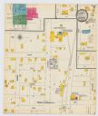
| Date: | 1908 |
|---|---|
| Description: | A detail of a Sanborn map showing the area around North Franklin, North Blair and North Hancock Streets. |

| Date: | 10 1898 |
|---|---|
| Description: | A detail of a Sanborn map including Lake Front and Lake Lawn areas by Langdon Street. |

| Date: | 1908 |
|---|---|
| Description: | A detail of a Sanborn map showing the North Blair Street area. |

| Date: | 1785 |
|---|---|
| Description: | Map of part of North America engraved and hand-colored (the light brown design is a superposition of the map and cartouche derived from the oxidation of th... |

| Date: | 1846 |
|---|---|
| Description: | This map is paint and ink on board with relief shown pictorially. The map was planned by Alfred Ames, drawn by one daughter and painted by another daughter... |

| Date: | 1908 |
|---|---|
| Description: | A detail of a Madison Sanborn map that includes the University of Wisconsin Boat House, UW Gymnasium & Armory (The Red Gym), fraternity houses, and the YMC... |

| Date: | 1903 |
|---|---|
| Description: | This maps shows what may be Ho Chunk Native American burial mounds. Also noted on the map is the Fox River, the Doty homestead, stockade embankment, the We... |
| Date: | 1900 |
|---|---|
| Description: | A Sanborn map of a portion of Seymour, Wisconsin. |

| Date: | 1918 |
|---|---|
| Description: | This is a collection of two maps. One map is blue line print that includes illustrations and shows the location of buildings, gardens, plant life, and spri... |

| Date: | 1810 |
|---|---|
| Description: | This map shows lot and block numbers, streets, and the public square. The bottom right margin reads: "Robert M. Eberts, Henry S. Baird, A.G. Ellis, R.S. Sa... |
If you didn't find the material you searched for, our Library Reference Staff can help.
Call our reference desk at 608-264-6535 or email us at:


