 Filter: Categories of Wisconsin Historical Images
Filter: Subject of Drawing
Filter: Year of 1900-1999
Filter: Type of Map or Atlas
Filter: Year of 1910-1919
Filter: Categories of Wisconsin Historical Images
Filter: Subject of Drawing
Filter: Year of 1900-1999
Filter: Type of Map or Atlas
Filter: Year of 1910-1919

| Date: | 1910 |
|---|---|
| Description: | This map is ink on paper. Shows Bruce’s proposed railway route and Moon’s railroad survey route along the Flambeau River, in parts of Lake and Eisenstein t... |
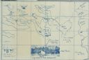
| Date: | 1914 |
|---|---|
| Description: | A map, hand-drawn by Carl Greene, of the McFarland Lake (Minnesota) region. The map also includes several clever, humorous drawings referring to some membe... |
If you didn't find the material you searched for, our Library Reference Staff can help.
Call our reference desk at 608-264-6535 or email us at: