 Filter: Categories of Wisconsin Historical Images
Filter: Subject of Drawing
Filter: Year of 1900-1999
Filter: Type of Map or Atlas
Filter: Categories of Wisconsin Historical Images
Filter: Subject of Drawing
Filter: Year of 1900-1999
Filter: Type of Map or Atlas

| Date: | 1927 |
|---|---|
| Description: | Blueprint-style map of Frost Woods on the shore of Lake Monona. The map indicates the locations of Indian mounds, an Indian camp, and various plants. There... |

| Date: | 1937 |
|---|---|
| Description: | A pictorial, hydrographic map shows sailing courses, historical and contemporary coastal attractions, roads, and the contour depths of Green Lake, Wisconsi... |

| Date: | 1930 |
|---|---|
| Description: | These 40 hand-drawn maps depict the survey townships in Oneida County, Wisconsin, on printed township grids. Lakes, rivers, and waterfront properties are d... |

| Date: | 1910 |
|---|---|
| Description: | This map is ink on paper. Shows Bruce’s proposed railway route and Moon’s railroad survey route along the Flambeau River, in parts of Lake and Eisenstein t... |

| Date: | 1978 |
|---|---|
| Description: | Bird’s-eye view map. Shows Madison from the edge of Lake Monona stretching west. Above the map are clouds and in the distance is the edge of the world and ... |
| Date: | 1914 |
|---|---|
| Description: | A map, hand-drawn by Carl Greene, of the McFarland Lake (Minnesota) region. The map also includes several clever, humorous drawings referring to some membe... |

| Date: | 1909 |
|---|---|
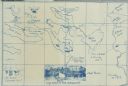
| Description: | A cyanoprint map of The Gang's journey down the Presque Isle River. There are small drawings around the border depicting the adventures of The Gang and Car... |

| Date: | 1909 |
|---|---|
| Description: | A hand-drawn and illustrated map of The Gang's trip from their seventh camp to Lake Superior. |
| Date: | 1900 |
|---|---|
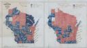
| Description: | Hand-drawn and colored maps of Wisconsin showing how each county voted in the gubernatorial race of 1865, and on a referendum regarding suffrage for Africa... |

| Date: | 1959 |
|---|---|
| Description: | An illustrated map showing American Indian communities in the United States. |

| Date: | 1900 |
|---|---|
| Description: | A hand-drawn map of the battlefield of the Battle of Chickamauga. |
If you didn't find the material you searched for, our Library Reference Staff can help.
Call our reference desk at 608-264-6535 or email us at:
