 Filter: Categories of Wisconsin Historical Images
Filter: Subject of Drawing
Filter: Subject of landforms
Filter: Categories of Wisconsin Historical Images
Filter: Subject of Drawing
Filter: Subject of landforms

| Date: | 1955 |
|---|---|
| Description: | Artist's conception of ancient village of Aztalan, fortified with high walls surrounding it. |
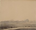
| Date: | 07 10 1849 |
|---|---|
| Description: | The clay hills that were formed by the Sweetwater River in Wyoming; sketched by Wilkins on his 151-day journey from Missouri to California on the Overland ... |
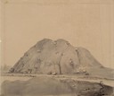
| Date: | 07 10 1849 |
|---|---|
| Description: | Independence Rock (the perceived midway point on the Oregon Trail),Wyoming, with two wagons unhitched at the base of the rock; sketched by Wilkins on his 1... |

| Date: | 06 20 1849 |
|---|---|
| Description: | Jail and Courthouse Rocks in Nebraska; Sketched by Wilkins on his 151-day journey from Missouri to California on the Overland Trail (also known as the Oreg... |
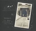
| Date: | 1911 |
|---|---|
| Description: | Frank Drew walks a set of railroad tracks near the entrance into a tunnel. The other end of the tunnel can be seen in the distance. A hand-drawn border fea... |
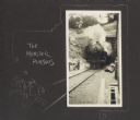
| Date: | 1911 |
|---|---|
| Description: | Front view of train emerging from a tunnel. A hand-drawn border features two male figures running away from the train and reads, "The monster pursues." |

| Date: | 1911 |
|---|---|
| Description: | View from inside railroad tunnel of four men walking near the entrance on railroad tracks. A hand-drawn border features a pennant with the letter "A" on it... |
| Date: | 1911 |
|---|---|
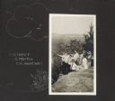
| Description: | A group of individuals are gathered on a bluff. One man is pointing off to the left, and the rest of the group gazes in that direction. Features a hand-dra... |
| Date: | 1911 |
|---|---|
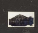
| Description: | View from lake of the bluff along shoreline of Lake Flora Dell. There is a hand-drawn decorative border, moon, stars and clouds, and the word "Finis." |

| Date: | 1612 |
|---|---|
| Description: | Map of New France, the area that is now eastern Canada and north eastern United States, showing lakes, rivers, and landforms. The locations of several Nati... |
If you didn't find the material you searched for, our Library Reference Staff can help.
Call our reference desk at 608-264-6535 or email us at:
