 Filter: Categories of Wisconsin Historical Images
Filter: Subject of Drawing
Filter: Subject of lakes
Filter: Categories of Wisconsin Historical Images
Filter: Subject of Drawing
Filter: Subject of lakes

| Date: | 1852 |
|---|---|
| Description: | Pencil drawing of view overlooking Madison. The sketch looks down North Hamilton Street from the capitol. Rutted, irregular streets and frame houses mark ... |
| Date: | 1911 |
|---|---|
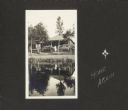
| Description: | View of Frank and Lillian Drew's cottage on Lake Flora Dell. Their daughter, Delia Drew King, is on the steps. "Home Again" is written along the right side... |
| Date: | 1911 |
|---|---|
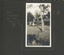
| Description: | View of the Drew family cottage on Lake Flora Dell. A caption of "The Cottage by the Sea" is to the left of the photograph, in addition to a decorative bor... |
| Date: | 1911 |
|---|---|
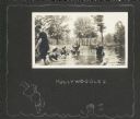
| Description: | Several women and one man wade in Lake Flora Dell. Delia Drew King is second from left, in a white straw hat. A hand-drawn caption beneath the photograph r... |
| Date: | 1911 |
|---|---|
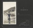
| Description: | Delia Drew King wades in Lake Flora Dell. There is a hill and shoreline in the background, and a group of people stands near a pier behind Delia. A hand-dr... |

| Date: | 1911 |
|---|---|
| Description: | A group of men, women, and children pose on a bluff above Lake Flora Dell. In the background are several cottages surrounded by trees near the shoreline of... |
| Date: | 1911 |
|---|---|
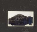
| Description: | View from lake of the bluff along shoreline of Lake Flora Dell. There is a hand-drawn decorative border, moon, stars and clouds, and the word "Finis." |

| Date: | |
|---|---|
| Description: | Wisconsin promotional decal with a drawing of a hooked muskellunge leaping out of the water. |

| Date: | 1927 |
|---|---|
| Description: | Blueprint-style map of Frost Woods on the shore of Lake Monona. The map indicates the locations of Indian mounds, an Indian camp, and various plants. There... |

| Date: | 1937 |
|---|---|
| Description: | A pictorial, hydrographic map shows sailing courses, historical and contemporary coastal attractions, roads, and the contour depths of Green Lake, Wisconsi... |

| Date: | 1930 |
|---|---|
| Description: | These 40 hand-drawn maps depict the survey townships in Oneida County, Wisconsin, on printed township grids. Lakes, rivers, and waterfront properties are d... |

| Date: | 1978 |
|---|---|
| Description: | Bird’s-eye view map. Shows Madison from the edge of Lake Monona stretching west. Above the map are clouds and in the distance is the edge of the world and ... |
| Date: | |
|---|---|
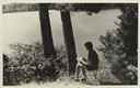
| Description: | Young camper seated on stool on a hill overlooking the lake. She has a sketchpad and pencil in hand. |
| Date: | |
|---|---|
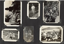
| Description: | Page from Joy Camps photo album displaying six photographs. The one on the upper left shows three campers sitting in a rowboat along the shoreline sketchin... |
| Date: | 1851 |
|---|---|
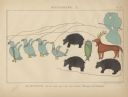
| Description: | Pictograph E., Plate 63, "Kaizheosh, and his Band from Lake Vieu Desert. Michigan and Wisconsin." A group of symbols including birds, animals, a fish and a... |
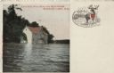
| Date: | |
|---|---|
| Description: | A colorized postcard view of a boathouse with stairs leading from the water's edge to the second floor. There is an illustration of an elk with a heart on ... |
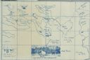
| Date: | 1914 |
|---|---|
| Description: | A map, hand-drawn by Carl Greene, of the McFarland Lake (Minnesota) region. The map also includes several clever, humorous drawings referring to some membe... |

| Date: | 1909 |
|---|---|
| Description: | A hand-drawn and illustrated map of The Gang's trip from their seventh camp to Lake Superior. |

| Date: | 1612 |
|---|---|
| Description: | Map of New France, the area that is now eastern Canada and north eastern United States, showing lakes, rivers, and landforms. The locations of several Nati... |

| Date: | 01 10 1923 |
|---|---|
| Description: | Drawing of aerial view of Harvester Works in Hamilton, Ontario, in Canada. |
If you didn't find the material you searched for, our Library Reference Staff can help.
Call our reference desk at 608-264-6535 or email us at: