 Filter: Categories of Wisconsin Historical Images
Filter: Subject of Drawing
Filter: Type of Map or Atlas
Filter: Subject of human settlements
Filter: Categories of Wisconsin Historical Images
Filter: Subject of Drawing
Filter: Type of Map or Atlas
Filter: Subject of human settlements

| Date: | 1927 |
|---|---|
| Description: | Blueprint-style map of Frost Woods on the shore of Lake Monona. The map indicates the locations of Indian mounds, an Indian camp, and various plants. There... |

| Date: | 1937 |
|---|---|
| Description: | A pictorial, hydrographic map shows sailing courses, historical and contemporary coastal attractions, roads, and the contour depths of Green Lake, Wisconsi... |

| Date: | 1712 |
|---|---|
| Description: | This drawing, based on an 1897 survey, appeared in the 1899 Proceedings of the State Historical Society of Wisconsin, accompanying Publius V. Lawson's arti... |

| Date: | 1910 |
|---|---|
| Description: | This map is ink on paper. Shows Bruce’s proposed railway route and Moon’s railroad survey route along the Flambeau River, in parts of Lake and Eisenstein t... |

| Date: | 1978 |
|---|---|
| Description: | Bird’s-eye view map. Shows Madison from the edge of Lake Monona stretching west. Above the map are clouds and in the distance is the edge of the world and ... |

| Date: | 1828 |
|---|---|
| Description: | Map of the Louisville and Portland Canal on the Ohio River. The map shows Louisville, Shippingsport, Clarksville, Jeffersonville, Gravel Island, Corn Islan... |

| Date: | 1882 |
|---|---|
| Description: | Plat map of the village of Dunbarton, received by the Lafayette County Register's Office on September 22, 1892. Certification by the surveyor, Albert Pool,... |

| Date: | 1836 |
|---|---|
| Description: | This map shows lot and block numbers, streets, a proposed canal basin, Fort Winnebago, and the Wisconsin and Fox Rivers. Relief is shown by hachures and no... |
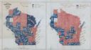
| Date: | 1900 |
|---|---|
| Description: | Hand-drawn and colored maps of Wisconsin showing how each county voted in the gubernatorial race of 1865, and on a referendum regarding suffrage for Africa... |

| Date: | 1959 |
|---|---|
| Description: | An illustrated map showing American Indian communities in the United States. |
If you didn't find the material you searched for, our Library Reference Staff can help.
Call our reference desk at 608-264-6535 or email us at:
